In short:
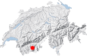
- Starting point: Zinal
- Total duration: 8 hours
- Difficulty: T3 - Challenging Mountain Hikes
- KMZ file for Google Earth
- Profile (up & down):
- Aloneness index:

Maps:
- Extracts:
1:25'000 1:50'000 1:200'000 - Swisstopo shop:
1:50'000
5006
Matterhorn - Mischabel
(composite)
Links (click on flag):
 Notes on Cabane Tracuit and the quality of its welcome, Guide des refuges de haute et moyenne montagne by Markus Jaton.
Cabane de Tracuit, Combautanna
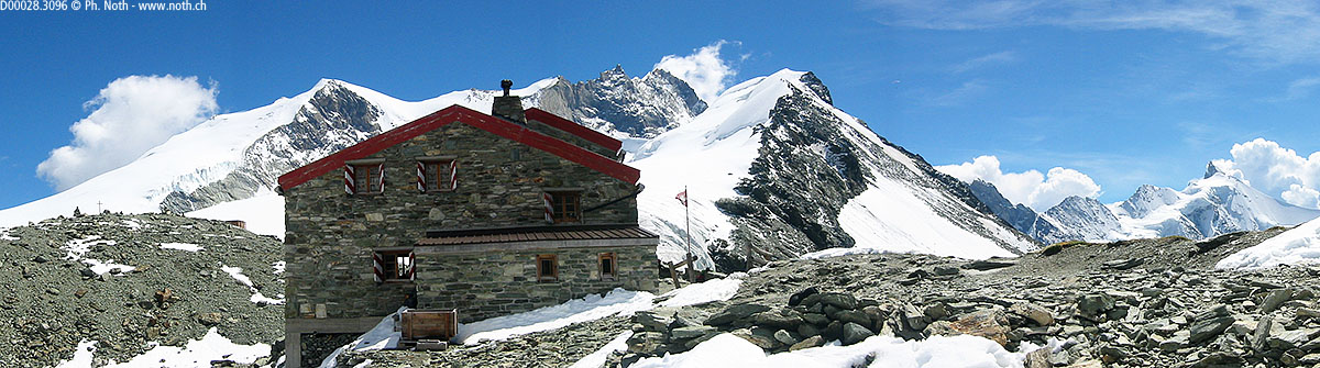
The Cabane de Tracuit (3258m, 10,689ft) is one of my three favourite, most spectacular alpine hikes (the other two being Bertol and Grand Mountet). The way up is tough, but, once you're there, the view of the Zinal 4000 peaks is magnificient.
The views are similar to those of the Grand Mountet, only there is more distance to fully admire the Grand Cornier, the Dent Blanche, the Obergabelhorn, and the very elegant Zinalrothorn (see picture 3). You're also at the foot of the Weisshorn, another famous alpine 4000, and very close to the Bishorn.
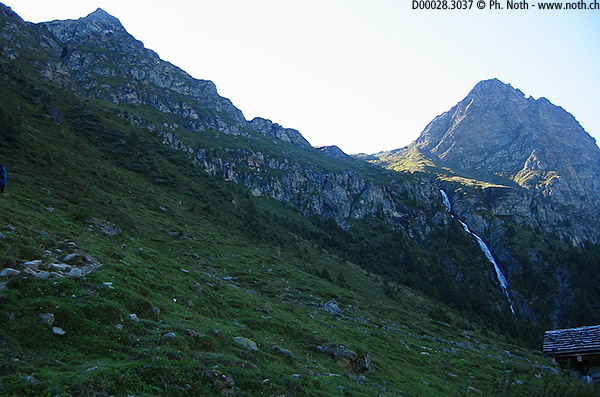
You can leave your car at the small car park located off the road behind the Hôtel des Bouquetins or set off on foot from the centre of Zinal. You have to climb the east side of the valley, and it's no piece of cake! You'll find that out right after you set off: steep twisting paths in the forest, undergrowth, and pastures. On high, you'll spot a waterfall rushing into the indentation at the foot of the Roc de la Vache. That's our intermediary goal: the upper pastures of Tracuit, some 800m (2625ft) higher.
Fortunately, this side remains in the shade in the morning. When you're making your way back down in the intense heat of the afternoon, you realize your luck having been in the shade. The path leads to the Barme stream. Wide and well-kept, it goes off to the left before returning to the right in a passage that isn't too steep over a rocky bore. The final metres before you reach the shelf merge with the torrent's bed. Walk with care! The humidity makes the stones very slippery. After 90 minutes, you reach the first level, the Tracuit pastures. On the right-hand side, a path comes down from the Roc de la Vache.

)
You can already make the hut out on the left, next to the glacier exceeding the ridge of the Diablons. The path goes precisely in that direction, past the Combautanna chalet (cows). Don't forget to turn around to watch the Zinal 4000 slowly reveal their beauty.
You wander through the pastures to about 2800m (9514ft). From that point, you make your way along a dark scree slope with big blocks scattered here and there. You reach a rocky spur the lower part of which you follow up to the last obstacle before you reach the hut: a narrow shaft with a rope. The climb poses no problem at all.
At the top, you find the glacial plateau of Tourtemagne. And just a few metres further along its edge, after 4.5 hours of effort and approximately 1600m (5250ft) of difference in altitude, you arrive at the pretty, grey-red Tracuit hut. The Bishorn (4153m, 13,625ft) appears so close and so easy to climb that, for a moment, you may forget that it's also a 4000 that peaks 900m (2953ft) higher up.
The same itinerary is your best bet to make your way back down. Other possible variants (Roc de la Vache or Ar Pitetta and then Le Chiesso) would only make a long, trying hike even longer and more trying. It takes you 2 hours 45 minutes to make your way back down.
[Updated 15-Mar-2014: Since June 2013, the cabin has a new "outfit", decidedly high-tech. The old-style stone house as pictured in photo 1 does not exist any more])

