In short:
- Starting point: with a car: park at Tréléchamps (Tré-le-Champ), on the Col des Montets road; with public transportation: the tiny train station of Montroc, on the line Chamonix-Martigny
- Total duration: 3 hours up, then 1 hour down to Flégère. After the hike, a cabin and a train ride will bring you back to your starting point
- Difficulty: T2 - Mountain Hikes (despite numerous ladders quite easy)
- KMZ file for Google Earth
- Profile (roundtrip):

- Aloneness index:

Maps:
- Extracts:
1:25'000 1:50'000 1:200'000 - Swisstopo shop:
1:50'000
Mont-Blanc - Grand Combin
5003
Links (click on flag):
 This same hike, reported by Pierre-Alexandre on his webspace which contains 89 tours in the Mont-Blanc region
- Report and pictures on Randomandie.ch.
- An alternate itinerary avoiding la Flégère: up the ladders to Lac Blanc, then return through La Remuaz back to Col des Montets. Recommended.
Grand Balcon Sud, Lac Blanc
Not far from Chamonix near the Swiss border, the Lac Blanc (white lake) is one of the most reputed outings in the region. Its balcony localisation on the south-facing mountain side opposite the Mont Blanc range means it provides excellent views towards the Mont Blanc, its four-thousanders and its glaciers.
The downside of this is that as it's an extraordinary site which can be reached fairly easily, it's just hustle and bustle all day long. If the climb up to the Col des Montets is to be recommended (about 3 hrs), the way down to La Flégère is like swimming against the current. Indeed, many walkers make it to the lake by the shortest route - which is actually understandable.
So, if I was going to do this walk again, I'd opt for the alternative route given by AltitudeRando (see links): the same ascent as described here, but the upper La Remuaz path for the way back. This provides several advantages: it avoids the main flow of walkers around La Flégère, it means you don't need to take the train and cable-car so you save on that and you'll get more stunning views on the way back.
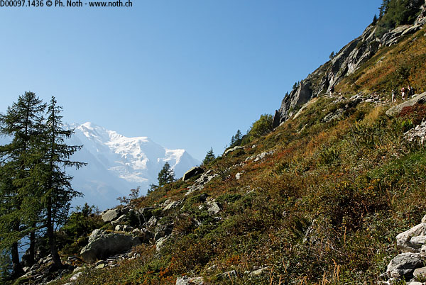
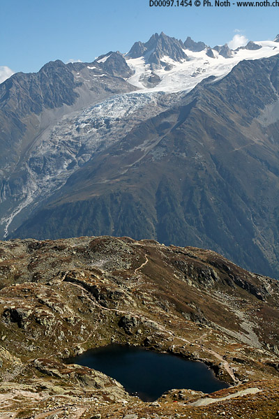
Between the Col des Montets and the village of Argentière, you will find a car park on the edge of the road, at Trélechamp (or Tré-le-Champ). A path leads off from the car park up across the slope and into the forest, soon mostly alders. Soon, as you can see on photo 1, the Mont Blanc takes its place as the background for this walk.
After about ¾ hr, you'll come to a junction from where a path heads back down towards Argentière. Take care to stay on the upwards path which leads up well to the right. About ¼ hr later, you'll come across a rocky outcrop. This is the Aiguillette d'Argentière, where the route goes up ladders and climbs the Deviets cliff. For the next 15 minutes, you'll be climbing a succession of stairs and short easy ladders. Then after a break only a few minutes long, it starts again. This time it'll be mostly steps made out of wooden logs and 2 or 3 ladders - again for about 15 minutes. At the end of this awkward stretch, you'll have reached an altitude of about 2000m. Although for me it was a first time with so many ladders, this passage didn't actually make the walk difficult. In my opinion the route is well protected and it is probably easier to climb up this kind of route, which is the way described here, rather than trying to come back down it.
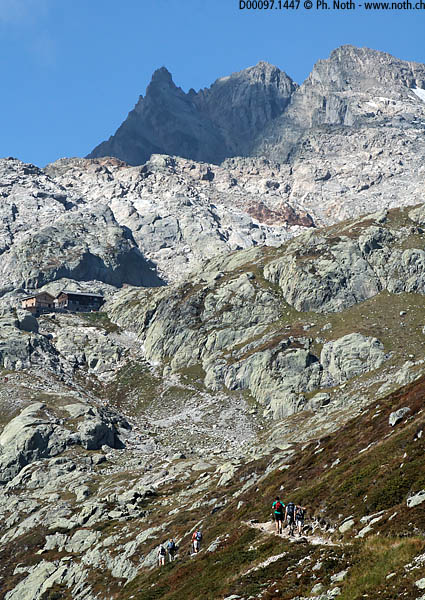
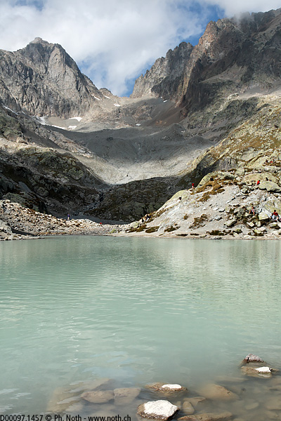
After a few hairpins in among the alders, you'll come to an intersection with a big cairn (altitude 2136m, 1¾ hrs from Trélechamp). The Lac Blanc is now only 45 minutes away and you can make out the 2 huts by the lake up to the left. The path continues along the mountain side and is much easier now. In hollows to the right of the path several lakes look like pleasant spots for a dip. The Chéserys lakes are one of the last places for a quiet break or picnic before meeting up with the crowds at the Lac Blanc.
The path gets noticeably steeper again a couple hundred metres before the Lac Blanc and steps have been carved out in the limestone slabs. You'll finally reach the Lac Blanc in about 2¾-3 hours depending on how long you stop off for photos. The roundabouts are worth exploring.
The descent route I chose took me across the bridge and down to La Flégère in about 50 minutes. From there the cable-car takes you back down to Praz de Chamonix. At Praz, find the small railway station, take the train towards the Col de Montets and don't forget to get off at Montroc. A path leads back to the Trélechamp car park in about 10 minutes from the Montroc station (just left of the railway tunnel). But as I said at the beginning of this account, it's probably nicer to come back from the Lac Blanc via the Chéserys lakes and then the La Remuaz lake and the Col des Montets. On my map, a path heads off right from the Col des Montets and comes out on the road just by the Trélechamp car park.
