In short:
- Starting point: Valbella, at the very end of the Calanca valley (road ends here, parking in the forest)
- Total duration: 5 ½ hours
- Difficulty: T2 - Mountain Hikes
- KMZ file for Google Earth
- Profile (up & down):

- Aloneness index:

Maps:

Links (click on flag):


 Guide of the Trescolmen lake, part of a collection edited by Banca del Gottardo and devoted to the alpine lakes of Ticino. What a marvellous project! All 32 brochures can be read online at the address www.laghettialpini.ch or obtained on request to the bank.
- Ticino hikers who did the same excursion... except they did it in the rain!
- Hike report on Hikr.org, written by Mauro and Alessandra. Can also be found on their website Ariafina: Ariafina: Lagh de Trescolmen.
Lagh de Trescolmen, Bocchetta de Trescolmen
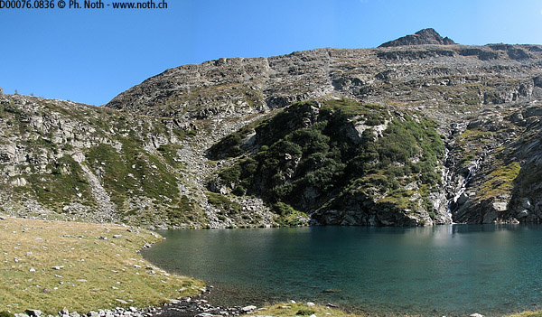
The Bochetta de Trescolmen is a passage between the wild Val Calanca valley and the Mescolcina valley along which runs the main road up to the San Bernardino Pass. The "local attraction" is the small Trescolmen lake which changes colour from blue to green or black depending on the weather.
Strictly speaking the lake is in the Grisons district. However the culture, dialect and architecture are decidedly similar to those of the Tessin region, at least for a "foreigner" like me from French-speaking Switzerland. The surrounding mountains belong to the Tessin Alps.
The starting point is the small car park (max. 10 spaces) on the way out of the village of Valbella. The pedestrian signpost shows that the route heads down through the woods towards the Calancasca river and that the walk to Alp Trescolmen lasts 2 ½ hrs.
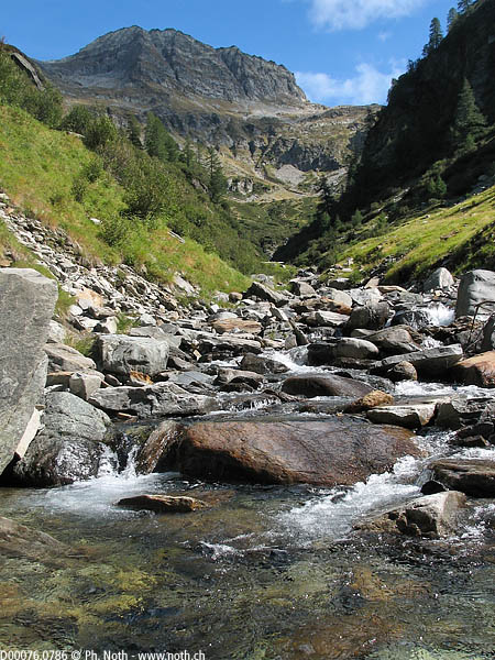
I immediately felt like I was in Nepal again. First because the path takes you down to cross the river and then straight back up the other side, just like when trekking in Nepal. And also because the path winds through a pine forest that overhangs a roaring mountain stream: the Ria de Campalesc.
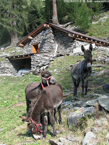
Within an hour you'll reach Cascinot where you'll find a chalet and some very nosy donkeys that followed me for a few minutes. A little farther on, you'll come across the stream again. Here a path is supposed to head off towards the Alp del Largè on the other side of the mountain. On the national map there seems to be an interesting loop to do by taking the main path up to the lake and then coming back via this balcony route under the Piz del Largè. Unfortunately, the leaflet from the Banca del Gottardo (Gothard bank) states that the path is deteriorated and this kind of warning should not be overlooked, especially in the Tessin region. In fact even the normal path becomes quite uncomfortable higher up with slippery stones and many overgrown hazelnut trees and junipers. It seems that Mother Nature has more of her own way here than on the mountain hut paths in the Valais! The best choice is therefore up and back via Alp de Tresolmen since hard as I tried there was no sign of a path up towards Alp de Largè.
So let's follow the "normal" Via Alpina path which gets steeper and steeper since it follows the stream which itself dives down umpteen waterfalls. In a particularly steep and narrow portion a herd of sheep hindered my progress - not easy to get through without getting mucky!
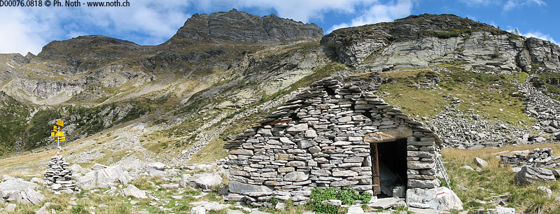
After 2 hrs 10 minutes walking, at about 1950 m (6398 ft), you'll finally make your way out of the gorge. Tree cover becomes sparser as Alp de Trescolmen gets closer. You'll be able to see where the lake lies up above since you can make out a slight dip in the ground from which the stream flows. Cross the stream (no bridge) to reach the shepherds stone hut at the Alp de Trescolmen after about 20 minutes walking in between the alder trees. In all, this adds up to 2 ½ hrs as planned.
The surrounding ground is quite marshy. Look for the large flat stone near the hut with engravings carved out by a shepherd in the fifties - quite touching. The carved letters give the sheperds name and the years he spent tending his herd up here. The Alp (alpine meadow) is really beautiful as you can tell from the lyrical description given by the author of the Banca del Gottardo leaflet:
"The extent [of the surrounding mountains] makes the pastoral hut look tiny, here where primitive herdsmen kept their livestock, frightened by the greatness of the place, daytime flashes and stories told by firelight."
The Trescolmen lake is now only 5 minutes away and although you can't see it from the shepherd's hut you can feel its nearness. You can choose to rest by the lake or climb a little more up to the Bochetta da Trescolmen pass. The climb up between the rocks and short grass is pleasant enough even though there are plenty of midges around. A loud buzzing noise made me look up to find myself face-to-face with a half decayed dead sheep.
You'll reach the pass in about half an hour and get a great view out towards many unknown peaks. They aren't very high, 2161m (7090ft), but fairly abrupt. For instance, when I was down in Alp de Trescolmen and looking at my map I couldn't work out where the path up to the ridge and then on to Pian Grand could possibly lie.
The way back down along the same path is tiring, especially from the river on. The path is narrow, overgrown with bushes and covered with many rocks that are always "the wrong way up" and sloping downwards and so call for extra care. Luckily this portion is not too long, only about 45 minutes. From Cascinot onwards you can relax because all the hard work is now behind you. You'll reach Valbella about 1 ½ hrs after leaving Alp de Trescolmen.

