In short:
- Starting point: Tierfed, between Linthal and Klausenpass
- Total duration: 7 ½ hours
- Difficulty: T2 - Mountain Hikes
- KMZ file for Google Earth
- Profile (up & down):

- Aloneness index:

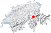
Maps:

Links (click on flag):
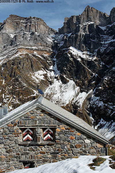
Fridolinshütten
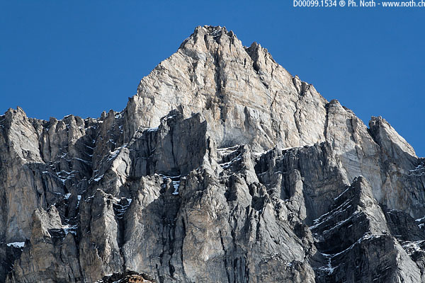
At an altitude of 3614m (11,857ft), Tödi is the main peak of the Glarus Alps, and simply one of the alpine giants since it was the goal of some of the first alpine expeditions in the 19th century. Fridolinshütte (or Fridolinshütten, as there are actually 2 huts) serves as the base camp for its ascent. Although the hut is not particularly high perched (2111m, 6926ft), the surrounding glaciers and peaks provide a special high mountain atmosphere.

This walk starts in Tierfed (also written Tierfehd) which is an industrial dead-end - its hydroelectrical power station is undergoing much extension work - up the Linth valley. A car park can be found just before the river at the surprising low altitude of 805 m which means it's one of the lowest starting points among the hikes on my website. However, this was not all bad for me since the first snow had just fallen at a slightly higher altitude.
Follow directions for "Pantenbrücke". Another sign indicates whether the keeper is in residence at the hut or not. This was not the case when I did the walk. For that matter I was the only person to make my way up to the hut that Tuesday in October. Follow the dirt track that rises steeply up into the woods. At this low altitude, the trees are still deciduous and not the usual pines seen on most mountain walks. The mountain sides get closer and closer until they form a narrow gorge.
After about a half hour, and just after a tunnel, you'll reach the Pantenbrücken. The end "n" in German shows it's a plural word and low and behold there are actually two bridges. One of the two is very old and after having been repaired over and over again is now encompassed within a more recent structure. You'll use the latter to cross the river Linth here for the first time.
After having crossed this obstacle, the path continues alongside the river which is now named the Sandbach (it becomes the Linth below Tierfed). The trough (U-shaped) valley widens up but its walls are yet more impressive and tower some 2000 meters up above with the Selbsanft. At the end of the valley is Tödi, snow-capped and even closer to the sky. The path alternates between the left and right banks of the river. After 1½ hour, you'll reach the Vorder Sand farm. To the left an auspiciously artificial waterfall pours out of the cliff.
From here it is practically flat up to Hinter Sand at an altitude of 1300m (4265ft) which takes another ¼ hour to reach. From next to the artificial lake, other paths head off towards other huts such as Planurahütte or Claridenütte to the right. The climb to Fridolinshütten is to the left across a meadow behind the Hinter Sand houses. I didn't find the footpath markings and signs very clear just here, probably because another path is indicated a little further on to the west. The climb up the mountain side starts surrounded by succulent green grass only to finish between shrubs and rocky ledges. Walking up the many hairpins you'll climb easily from 1300m to 1556m where a bridge will take you across the Bifertenbach stream (2½ hours, sign). The bridge leads the way into a beautiful small cirque called Tentiwang. Chamois play here under the Selbsanft peaks.

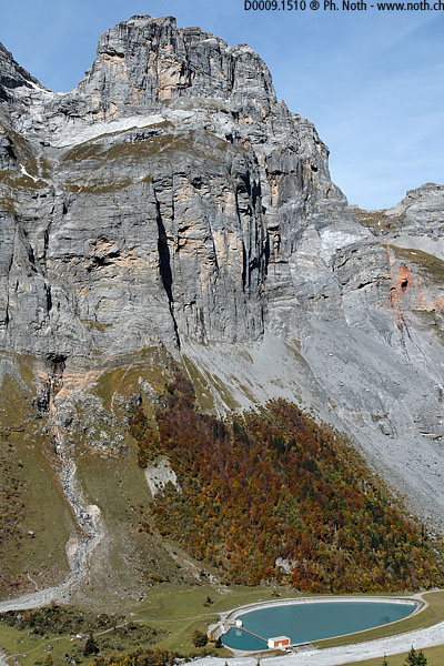
The path rises rapidly to the right (west), climbing the Ölplanggen slopes under the Ochsenstock peak. The hut is now close as a bird flies but for us there is still a 500m climb. The path crosses the Bifertenbach stream again below a waterfall. After climbing up through the meadows to the right where the ground is easier, the path heads back towards the stream at the top of the waterfall. Only another hundred meters to climb and you'll reach the hut (3¾ hours from Tierfed). A lake lies nearby but was hidden by the snow on my trip.
The site is just great for a mountain hut: Tödi (3614m, 11,857ft) towers just behind it - so close and yet so far! Not to mention the Bifertenfirn icefall, the jagged ridge between Bifertenstock and Selbsanft...
To get a closer view of the glaciers it's probably a good idea to continue on to the Grünhornhütte mountain hut, only another hour away. It's the oldest hut in Switzerland. I didn't myself try this out on account of the amount of snow and because the day was getting on. The way down is the same as the way up and lasts at the most 3 hours.
