News:
- New Ticinese hike: Val Calnègia 17-Jun-2015
- A Google Map page helps to locate all hikes of the region 30-Apr-2012
- Pilone, Capanna Salei has been translated 10-Sep-2011
- Photos and infos for 3 outings done in 2010: Rifugio Piano delle Creste, Laghetti d'Antabia, Bocchetta di Doia, Alpe di Categn and Gridone, Rifugio Al Legn. No report yet 20-Dec-2010
- Lagh de Trescolmen is now ready 9-Jun-2010
Ticino & Mesolcina

Among these hiking regions, Ticino holds a special place. There I found deeper and wilder valleys. Trails full of surprises, good or bad. Sheepfolds and pastures at the remotest locations. As explained by the author of the German website alpi-ticinesi.ch, here more than elsewhere, passages used by shepherds for centuries have fallen into oblivion, high passes are not used any more. My advice: unless you are a hardcore hiker, fearing neither heights nor tracks invaded by vegetation, it is worth asking around before venturing to an high alpe just because the national maps show there is a trail.
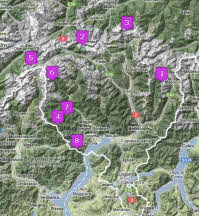
Click on the image to open a large overview of all hikes in Ticino and pick one through its location on the map.
