In short:
- Starting point: the village of Spruga (val Onsernone, Centovalli)
- Total duration: 5-6 hours
- Difficulty: T2 - Mountain Hikes
- KMZ file for Google Earth
- Profile (roundtrip):

- Aloneness index:

Maps:

Links (click on flag):


 Guide of the Salei lake, part of a collection edited by Banca del Gottardo and devoted to the alpine lakes of Ticino. What a marvellous project! All 32 brochures can be read online at the address www.laghettialpini.ch or obtained on request to the bank.
Pilone (Cima Pian del Bozzo), Capanna Salei, Laghetto dei Salei
Rising up between the remote Tessin region valleys of Vergeletto and Onsernone, and on the border between Switzerland and Italy, the Pilone mountain (also called Cima Pian del Bozzo) is a great place for walking at the beginning or towards the end of the season. Its bare slopes looking southwards are quickly free from snow.
It's hard to park in or around Spruga, a small village in the end of the Onsernone valley, and the road leading to the village is quite tortuous. All in all, 2 good reasons to take the local bus. In the absence of any signposts for Cima Corte, Salei or Pilone, I decided to head up behind the church. There, red and white markings can be found together with a sign indicating "Tessitura/Handweberei" (handweaving) and then stairs. Further on, a wooden signpost for "Salei" confirms that this is the right way. You'll soon leave the last houses of the village behind you and walk into the woods.

After about 15 minutes, you'll see the first "official" yellow Swiss footpath signpost. Follow Cima al Corte, Alpe Salei. The path becomes slightly less steep and you'll come across some houses again, some of which are beautiful traditional stone houses and others starting to fall down.
At Piansecco (1438m), continue following the signs to Alpe Salei. A pine forest has here paved the way with a layer of red orangy needles which feels just great underfoot. Shortly afterwards, at an altitude of 1450 m, make sure you do not follow the sign left for Pilone (Cima Pian del Bozzo) - you'll be coming back this way! Continue following the signs for "Alpe Salei". On the long traverse that now starts in the woods, you'll be surrounded by deciduous trees again and the soft bed of needles becomes a bed of leaves.

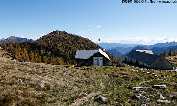
You'll reach Bivio Pesced (1740m) in about 1½ hours. Keep following the signs for Salei. The flattish area after the end of the forest offers a view over towards the ridge between Creste and Pizzo Zucchero which doesn't now look too far away. At Bivio Salei you'll again find a set of signs! You'll be going to Lago Salei later on but first it's better to visit the Salei hut so just head straight on. Even though there's a steep portion crossing the bed of a dry stream you'll soon be able to rest at Alpe Salei and its shelter. This first portion of the walk lasts 1¾ hours. From here it is possible to go back down the Val Vergeletto. For our route to PIlone, the simplest is to head back the way you came to the Lago Salei sign (a shortcut does exist). The shortcut can be found on the 1:25 000 map (it was not clear on another map I had when I did this walk) - still, it doesn't make much difference either time wise or effort wise. Now starts the climbs towards Laghetto del Salei. The path gets quite steep, especially just before the lake.
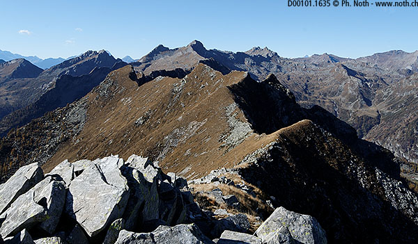
The lake's banks can be still frozen and it is of a beautiful deep blue colour. Leave the lake to your left and keep climbing towards a peak called Munzelüm. As the slope becomes gentler, you'll discover the long ridge that leads up to Pilone. After 2½ hours in all (without the breaks), you"ll reach Bochetta di Büsan, also called Passo del Büsan. This again is another way to access the Val Vergeletto. A few meters from there, a great cairn offers a magnificent view over the lake Maggiore and Ascona.
From there on you'll be walking in low grass and between large boulders. However the boulders are fairly scarce so there aren't too many rocky passages. Pilone is still there, far away at the end of the ridge. When I did this walk I thought I had to leave the path and head up a mount with steep northern sides but this would have been a mistake since it was Motto dei Ciapitt and not Pilone. You'll reach the summit of Pilone after about 3¼ hours in all.

The crest and the path following it continue far on to the west. But this would mean more time... Lower down to the north ends the Val Vergeletto, with some exciting walks (for another day): Alpe d'Arena, Alpe di Porcaresc... As for the view out toward distant high peaks, I must admit I didn't recognize much even though the autumn-time visibility was perfect.
The way down can be done so the walk is a loop. Indeed, you'll have to come back along the ridge to the pass (Bochetta di Busan), but then instead of going back down to the lake, take the path that goes along the west side of Munzelüm (in direction of Alpe Pesced). The path is not very clear at first but quickly becomes a proper trail even if it's narrower than the path up.
Alpe Pesced is just a large building next to a small stone house. The path then leads into the woods and meets up with the junction you passed on the way up (point 1450m). After crossing Piansecco again you'll reach Spruga after a 2-hour descent.

