In short:
- Starting point: Rotenschwand or Bodmi for the "short hike"; Tschieme or Schwendallmi for the full loop which I describe here
- Total duration: 6 hours (or 3 hours if shortened)
- Difficulty: T3 - Challenging Mountain Hikes (only tricky near Suggiture, otherwise it would have been T2 - Mountain Hikes)
- KMZ file for Google Earth (long variant)
- KMZ file for Google Earth (short variant)
- Profile (roundtrip, long):

- Profile (roundtrip, short):

- Aloneness index:

Maps:
Links (click on flag):
 Hike report on Hikr.org.
Augstmatthorn, Suggiture
When climbing the Augstmatthorn (2137m, 7011ft), you'll have a good chance to see its famous ibexes. When I went there, I found some of those animals near the summit on both sides of the path. This mountain offers a breathtaking panorama of the Bernese Alps and Lake Brienz. It can be visited in 2:30-3 hours going there and coming back, but I opted for a 5-6 hour tour.
Where to start the hike? I have no definitive answer to this question. What is certain is that I do not advise anybody to leave starting from the shores of Lake Brienz. Although there is a path from Niederried and another one from Oberried, you have to have a little bit of masochist in you to embark on this uninterrupted 1550-meter climb. Same for the descent. No, I think it is better to go through the softer slopes on the side of Habkern, Schwendallmi, Tschieme and Bodmi.
Habkern is the starting point for those who do not come by car. I would be surprised if postal buses coming from Interlaken go higher and beyond this village. But this should be checked anyway.
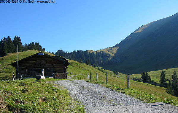
I recommend the farm in Rotenschwand, or lower, in Bodmi, for those who want to make a short hike. What I call a "short hike" is the climb to the summit via Bodmisegg, crossing Suggiture, then down to Bodmisegg. The estimated time: 3 hours. You will have to pay a toll at Tschieme for the right to use the road.
Schwendallmi (take the road left at the intersection of Schwendi) is an excellent starting point to begin the climb. But if you want to take my tour, you’ll end up at Tschieme and shall still have to go up for quite a long stretch.
Thus my choice fell on Tschieme. Advantages: no need to pay the toll (I was in a tight mood that day), and the car is in the immediate vicinity of the end of the downhill. Disadvantages: just a few places to park, and the first ½ hour walk on the road.
At Tschieme, I try to leave the asphalt going toward the farms where you see the sign that mentions “Augstmatthorn 3:20”. Another sign a little farther indicates simply "Bergwanderweg" to the right. Do not go there because that is the place where we will be going down. What we need, in a few words, is to follow the road until point 1472. As the path - although it was marked on my map - got lost in the high grass, I had to tell myself to cut through the meadow and find the road. I finally walked on the tar for 45 minutes before being able to go to the right to Bodmi.
At the chalets of Bodmi, where there seems to be a restaurant in the season, the Augstmatthorn is indicated to be at a 2h00-distance. The path follows a ridge (Bodmisegg) for 30 min. At that point it meets another path coming of Rotenschwand. The hike was, so far, not very pleasant. After the tar stretch, the path turned out into a path treaded by the hooves of cows. The low altitude makes the heat hardly bearable. A huge number of flies fly under my feet when I step next to a plant - always the same plant – whose name I do not know.
A fox first passes near me without even noticing me, and then it runs off as soon as it sees me. We continue to follow this grassy ridge while taking a curve toward the top of the Augstmatthorn. Above, the trail crosses the face which is still in the shadow of the Suggiture (downhill route for the short hike). We in fact soon arrive at a junction where we can choose between joining the Hardergrat by this way and continuing directly to the Augstmatthorn. And here we select the second option.
We get close to 1800 meters. The vegetation is now scarce, insects too. The air has become more breathable. I begin to appreciate the hike. The slope gets steeper as it goes over some rocks. Above this, there is nothing more than just grass - a slope of yellow and short grass which stops only at the summital ridge. You set foot on this edge after a 2:45-walk.
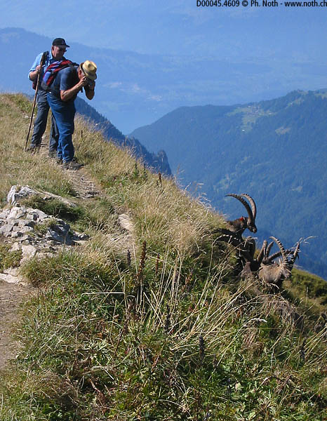
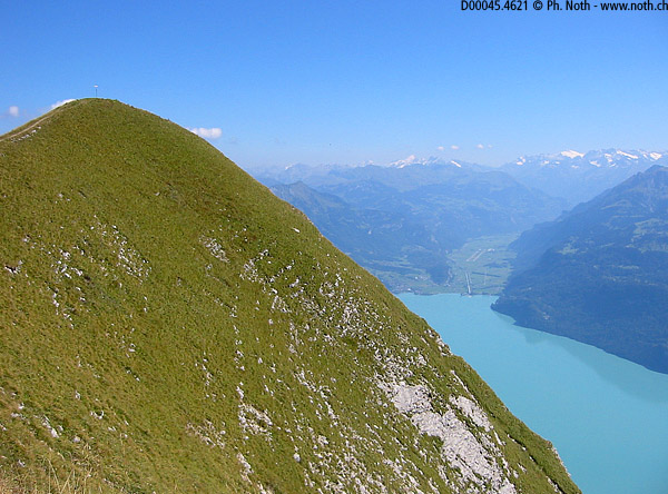
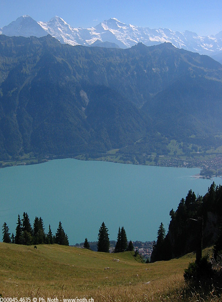
What a view! You see the turquoise water of Lake Brienz 1500m lower and the Bernese Alps right there in front of you. The Eiger, Mönch, Jungfrau, the Schreckhorn, Finsteraarhorn, the Wetterhorn, etc ... Let’s walk another 10min to north-east on the ridge to reach the top of the Augstmatthorn. Before getting there you might want to ask the ibexes to move a little away. The mountain is famous for its ibexes but I did not expect to see a herd grazing a few meters away from the path. One can almost touch them. It is true that since my trek to the Vanil Noir, in the Fribourg Prealps, I saw how these animals can accommodate with the presence of man. Contrarily to this, the chamois usually keep their distance.
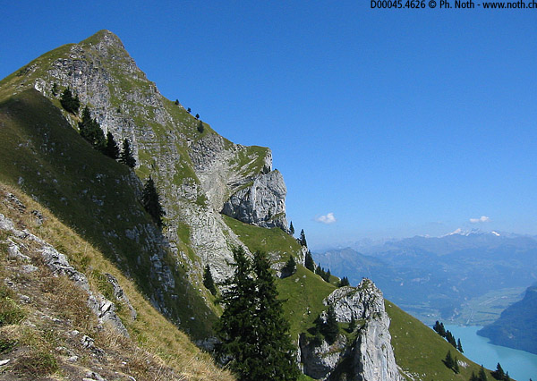
Going back, I chose to remain on the ridge until Horetalp (1h30 from the summit of Augstmatthorn). On the way, you climb up to a second summit, the Suggiture (2085m, 6841ft). Although it is a little less high than the Augstmatthorn, it is more impressive for hikers who are subject to vertigo. I can reassure you: the wide path rarely flirts with the steep precipice that falls into Lake Brienz. Still, the descent of the Suggiture causes me to have some adrenaline surges.
After 30 minutes spent to cross the Suggiture, you have the possibility to go return to Bomi by the path that I quoted earlier. For my part, I remained on the ridge. Another path descends the opposite side of the mountain. It literally plunges into the lake, at Niederried. Walking is now very easy because the mountain slopes are a bit smoothed out. You are still at a respectable altitude of 1750m when the real descent appears with the sign mentioning "Tschieme 1:10". As stated previously, 1h30 have passed since we left the summit of Augstmatthorn.
Still 45 minutes travelling partly on a gravel road - which does not lead to Tschieme but to Bodmi, so you must not follow it too long! - partly on a steep slope in the forest. The sound of the river Lombach marks the end of the descent. Walking along it for a few minutes, you find your car back at Tschieme or, for those who came by bus, the road to Habkern.

