In short:
- Starting point: Grimselpass (top of the pass road)
- Total duration: 3 ½ hours
- Difficulty: T3 - Challenging Mountain Hikes (unstable big boulders near the top require some care)
- KMZ file for Google Earth
- Profile (roundtrip):
- Aloneness index:

Maps:
Links (click on flag):
 Hike report on Hikr.org.
Sidelhorn
The Sidelhorn (2764m, 9068ft) is a summit that can easily be "conquered" starting from the Grimsel roadpass. Located on the border between the cantons of Bern and Valais, near the Urner Alps, this summit offers a very wide panorama of mountains and glaciers.
I often come back completely satisfied after a day of hiking. This time, I draw a more mixed personal set of results (yours will maybe be different). I enjoyed the variety of the landscapes and the route because, as many trails can be found all around, it is possible to make an interesting loop. My choice went to a climb via the north-east (Husegghütte) and then to a way going back down from the south (Triebtenseelicke, Chrizegge, Totensee), i.e. the same crossing as the one described on the German site machaon.de, but in the opposite direction. It is an itinerary that I strongly recommend, as it is neither too hard, nor too long. On the other hand, I did not want to walk on the asphalt road towards Berghaus Oberaar. Let’s talk about the negative side of the story. I certainly was not happy about the crowd that was concentrated at the top. No doubt, this mountain is extremely popular, even on a weekday! Finally, as beautiful as may be the landscape, we cannot ignore the numerous dams and roads made of concrete that mark this region of Grimsel.
The start is located on the top of the Grimsel roadpass. There you can find parking lots, restaurants, shops and other inventions to retain tourists in a hurry for just a moment (e.g. a park of marmots). During the first 10 minutes, you follow the asphalt road to the Oberaarsee. Then you borrow the path going up on the left (sign that says "Husegghütte" and "Sidelhorn").
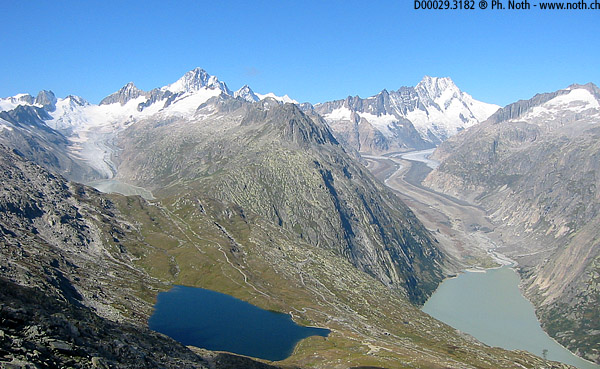
The terrain consists of large slabs of smooth granite that results from the presence of former giant glaciers. A small valley is covered with moss patches of an incredibly bright green. The climb is steep enough until the arrival at the Husegghütte (50 min. from the bottom) which, that day, was closed. On the hump on which the cabin is erected, you can enjoy a beautiful view. On the West, you see the glaciers (Oberaargletscher, Unteraargletscher) and the summits (Lauteraarhorn, Schreckhorn, Finsteraarhorn, all "4000" summits) of the Bernese Alps. Several artificial lakes receive water from these glaciers. On the East, you see the mountains in the canton of Uri, such as the Gärstenhörner peaks, just above the road going to the pass, and a very beautiful mountain that dominates all the others, the Galenstock (3585m, 11765ft).
You then go up the back side of the Sidelhorn, first fairly easily on a beautiful trail that meanders on the lower ridges of the mountain. But after a 1h30' walk, you have to climb the pile of boulders that build the last heights of the Sidelhorn, for which you must sometimes use your hands to pass the largest blocs. A path has been traced roughly well there in the middle. The cross that prevails at the summit is reached in 1:50, excluding the breaks.
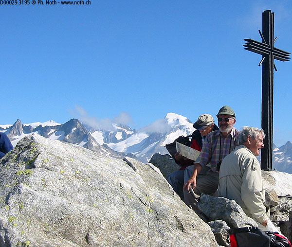
As a group of very noisy elderly people have taken up all the limited space of the summit, I immediately begin going down on the other side. It takes me 15 minutes to go to the Triebtenseelicke pass through chaotic blocks which are even bigger than on the other side. The main problem is to find stable stones and to have to make acrobatics to pass some levels higher than the others. But the slope is not dangerous and the direction to follow is obvious.
You quickly find a more enjoyable path, the one that links both sides of the Triebtenseelicke pass. In order to perform the same circuit that I am describing, you must turn south, i.e. go to the left when you have reached the pass. In the literature you find that the way going down by the north side is more often mentioned, towards the Triebtenseewli lake. I guess that this variant is less interesting because you soon reach a road.
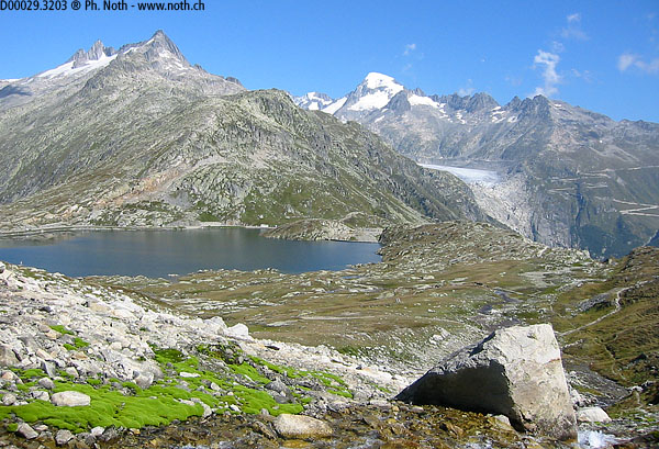
A 1:50000 map of the region, an item that is always useful when hiking, shows that you will go around the Sidelhorn by the south and return to our starting point. You must therefore always stay on the left, all the time. I was first startled by the lack of road markings and signs. But I believe I took a secondary path which was located higher, parallel to the marked paths. The gentle and regular slope makes the way going down very pleasant. You have in front of you the Galenstock and the Rhône glacier, which is the source of the river that bears the same name. I quickly saw and then joined the main path. Then you follow a creek to lake Totensee. Finally you go along the lake until the Grimsel pass. Total duration of the downhill: 1h30.

