In short:
- Starting point: Läger, cable car from Kandersteg
- Total duration: 6 hours
- Difficulty: T2 - Mountain Hikes
- KMZ file for Google Earth
- Profile (up & down):

- Aloneness index:

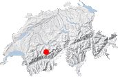
Maps:
Links (click on flag):
 Hike report on Hikr.org.
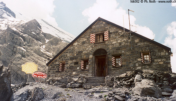
Fründenhütte
Facing the Blümlisalp massive, the Fründen cabin (2562m, 8405ft) overlooks the Oeschinen lake, 1000 meters below. It is a distant enough goal to escape the tourist crowds that invade the lake during the summer days.
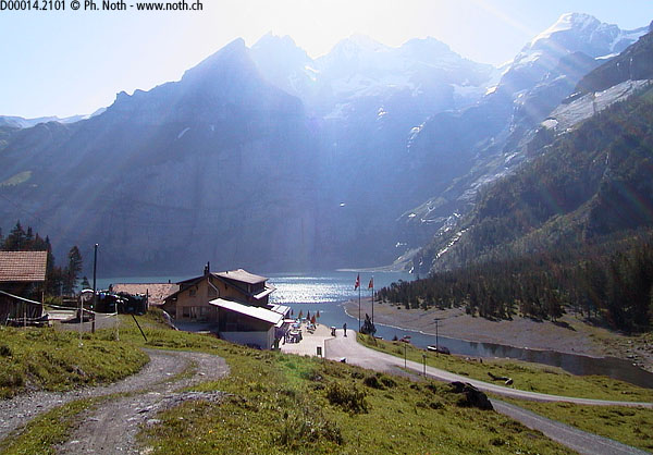
I'll describe the hike starting at Läger, the chair lift top station, located 15-20 minutes away from the lake. Leaving Kandersteg, one could also go up on foot instead of using the chair lift: the Oeschinensee is linked with Kandersteg by a private road and numerous trails. But hiking that stretch is of little interest.
So one should use the "prehistoric" chair lift that links Kandersteg to Läger and the Oeschinensee. Over there they call it "nostalgic", it is another way to see the things. In any case, it is the only chair lift that I know whose chairs are turned on the side and not facing the slope. Besides, the very low speed of this installation can create a long queue at the departure. A good reason to keep this hike preferably for a weekday.
At the mouth of the lake, where one finds some restaurants and souvenir shops, we go to the right. At first we cross a forest of small conifers during 15 minutes without much elevation gain. Then the path meets rocks and cliffs, its slope becomes more pronounced. Seen from the distance, it's indeed difficult to imagines a trail on this side of the lake. In spite of the difficult terrain, the path is very well maintained. Its regular slope helps keep a constant rhythm, which is very pleasant.
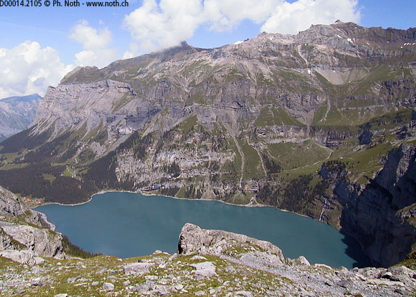
If in the beginning we were still greeting and being greeted by many walkers or picnickers, after one hour ascent we can begin to enjoy some privacy and the sound of the numerous cascades coming down from the glaciers high above the lake. We pass 3 of these cascades, the first, narrow and perfectly vertical, looking like a blade that would have incised the rock. Wooden bridges allow an easy crossing of the torrents.
On the other side of the Oeschinensee, it is possible to discern the trail that leads to the Blüemlisalphütte. Point 1936 of the map is reached after approx. 1 hour 45 min. We are now 400 meters above the lake, with 600 left to climb. Facing the summits of the huge massif of the Blümlisalp, we can maybe catch the spectacle of seracs breaking off their glaciers in a loud growl.
The trail climbs in zig-zags towards a rocky stretch which seems impassable at first sight, but the passage was so well designed that it is only a formality. This obstacle cleared (2 hours 15 min. after the start), we now have to ascend the final rocky spur, the one on which the Fründenhütte has been erected. It should take 30 minutes, and we do so by swinging left of this obstacle. Despite the well secured trail (steps hewn from the rock, cables), this stretch is a bit uneasy. Snow here could make these last hectometers tricky.
Apart from being very close to a glacier, the cabin does not offer fundamentally different views than the one gleaned below this last spur. We had roughly the same outlook of the Blümlisalphorn (3660m, 12008ft) and the Oeschinenhorn at the map points 2312 or even 1936.

