In short:
- Starting point: Griesalp (Kiental)
- Total duration: 7-8 hours
- Difficulty: T3 - Challenging Mountain Hikes
- KMZ file for Google Earth
- Profile (roundtrip):

- Aloneness index:

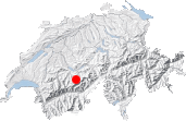
Maps:
Liens (cliquer sur le drapeau):
Gspaltenhornhütte, Sefinenfurgge
This original tour that does not lack in diversity takes you first of all to the Gspaltenhornhütte (2455m, 8054ft) via the valley and the glacier of Gamchi, located in the Blümlisalp massif. After that, via a little-known crossing, it leads you to the pass of the Sefinenfurgge (2612m/8569ft), from which you see the Eiger, the Mönch, and the Jungfrau, that famous threesome, and then back down to the starting point in the Kiental.
Very little information is available on the passage of the Trogegg. Right now, Google comes up with only 2 pages that give you little enlightenment on the subject when you type in that key word. This is a pity because the Gspaltenhornhütte-Sefinenfurgge link is a sublime 8-hour loop that takes you to the snow of the Blümlisalp, the dark stronghold of the Gspaltenhorn, and the very famous (too famous?) Schilthorn. It is mentioned in the Rother Berner Oberland Ostguide. Contrary to what is said in it, the path, though daring, is not difficult. But do find out beforehand whether the passage is snowbound.
The recommended starting point is the car park at the end of the Kiental-Griesalp route, near the bridge that spans the Gamchibach. Beyond that point, traffic is forbidden. This route, very steep and narrow in spots, is accessible by postal bus. Those who come by car theoretically have to pay a toll at Kiental, but do not ask me exactly where or when that toll is to be paid. As the saying goes, no one will be any the wiser!
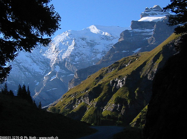
You walk along the road and pastures for 45 minutes, passing by the Golderli inn and then the farms of Steineberg. Asphalt gives way to gravel. The road becomes a pedestrian path at Burgli (farm). The way to the Gspaltenhornhütte is straight on. On the left is the Sefinenfurgge. As I had chosen to go to the hut first of all, that meant going straight on. But that does not mean that there is nothing to see. Here, at the end of the valley, the setting includes such delights as the Wildi Frau (3259m, 10,692ft) and, moreover, the wall of the Morgenhorn (3623m, 11,886ft).
The U-shaped valley of the Kiental narrows. At Gamchi (refreshment bar), it is closed off by a rock jam. You climb inside the cliff on the left-hand side and, at the same time, get a free shower, even with all your clothes on! The Blümlisalp massif is now gradually revealing itself to you: on the ridge, you can see the Hohtürli pass and even the silhouette of the Blüemlisalphütte.
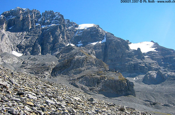
After a few sharp and difficult bends, you reach one of the lateral moraines of the Gamschigletscher (2 hours from the starting point). From here, you can see the top of the glacier (Gamchilücke) and just make out the hut.
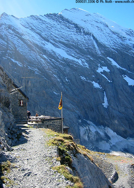
The last hour of the path to the hut can be summed up as a rise relatively tiring in the grass and then the scree of the slopes of the Bütlasse and the Gspaltenhorn. The hut nestles up against the rock on a projection easily reached by crossing it diagonally from the left.
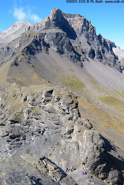
Once the break at the hut is over, the second stretch can be tackled. To do so, you have to backtrack a little to the fork toward Trogegg. Seen from the hut, this crossing of the ridge of the Bütlasse between 2 levels appears airy; actually, everything is so well set up that you do not notice the void. Just be sure to stay on the path - though this piece of advice appears obvious, it will not hurt anyone to be reminded.
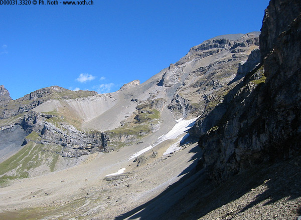
Behind Trogegg, a wild cirque opens up. You think that you see the Sefinenfurgge high up on the slope but the pass is located further behind. You execute a long crossing in stone-drains, end up reaching a few patches of left-over snow, and use a small ladder to reach a projection on which you will find the only grassy areas on the whole slope. That is followed by another abrupt and long rise in scree with a few cables in the most risky places, especially higher up.
After 1 hour and 30 minutes of solitary hiking from the Gspaltenhornhütte, you come across a pass that has no name. And here is where you see the Sefinenfurggee, directly opposite you. 30 more minutes and you are there. The highlight is the sight of the Eiger, the Mönch, and the Jungfrau.
And now there is the hike back down into the valley. This final stretch is more frequented, as the crossing of the Sefinenfurgge seems rather popular. It is one of the few itineraries of this site that I found in Lonely Planet Walking in Switzerland.
The extreme steepness of the slope under the Sefinenfurgge makes the first metres of the descent uneasy. Though there are steps, their worn state makes walking complicated. But the path soon becomes pleasant again. It winds across pastures, goes past a farm at Obere Dürrenberg, and arrives at another farm at Uf de Huble. From there on, it becomes a road suitable for motor vehicles but steep in places (I even fell once) that leads to Burgli, a third farm. Beware of its stupid dog that may bark and show its fangs after you have crossed its path.
At this point, the loop has been looped. All that is left to do is to follow the route - the same one that was used to begin the tour - back to the car park of Griesalp.
Summary:
Griesalp - Gamchi - Gspaltenhornhütte: 3 hours and 15 minutes
Gspaltenhornhütte - Trogegg - Sefinenfurgge: 1 hour and 30 minutes
Sefinenfurgge - Griesalp: 2 hours
The 8 hours that I mentioned includes long breaks at the hut and the pass.
Readers' comments:
I translated the following comment since it provides valuable feedback on the trail condition:
 From: Yannick Bersier

                  Sent: 28-Aug-2009


                  (...) i did the hike Griesalp, Gspaltenhornhütte, Sefinenfurgge, which is splendid. I'd like to inform you about the fee for the road between Kiental and Griesalp: 13.- roundtrip. This amount has been collected by a local agent at the bottom of the steep Griesalp road, it was around 4:30pm. As we arrived early morning at 6:30am and he was not there, I believe his duty ends sometime at the end of the afternoon, and that you did not meet him if you returned at a later time than we did.


                  After Gspaltenhornhütte, on the trail towards Sefinenfurgge, before the ladder, be sure to follow the new marking (left hand side). The old one (which takes you to the right and seems to be a shortcut) can be followed for a while, through a first easy snow field, but then comes a second snow field, biggera and steeper, on which I did not want to venture without crampons. That meant: turn back and some energy lost before the hard ascent to Sefinenfurgge.


                  The steps at Sefinenfurgge have been renovatd, they are perfect. The descent is steep but safe.

