In short:
- Starting point: Salzmatt (or Lac Noir/Schwarzsee)
- Total duration: 3 hours
- Difficulty: T2 - Mountain Hikes
- KMZ file for Google Earth
- Profile (up & down):
- Aloneness index:

Maps:
Links (click on flag):
 Hike report on Hikr.org.
Kaiseregg
This 2185m (7168ft) summit is located in the district of Singine, in the German-speaking region of the canton of Fribourg. The ascent is easy and very popular because the top is like a balcony with a view to the Bernese Alps.
This selected alternative is the shortest but also less convenient. Indeed, because of the start at Salzmatt (1637m, 5371ft), it is necessary to have your own vehicle. The way going to this isolated pass consists in a long detour going by the North, even flirting with the border of Bern. If I had not been invited, I myself would not have had the idea to start the tour at that place. You can, however, join Salzmatt since the Schwarzsee in one hour if you use the Riggisalp lift, or in less than two hours without the lift. The Schwarzsee, or Lac Noir, is very well served by bus from Fribourg.
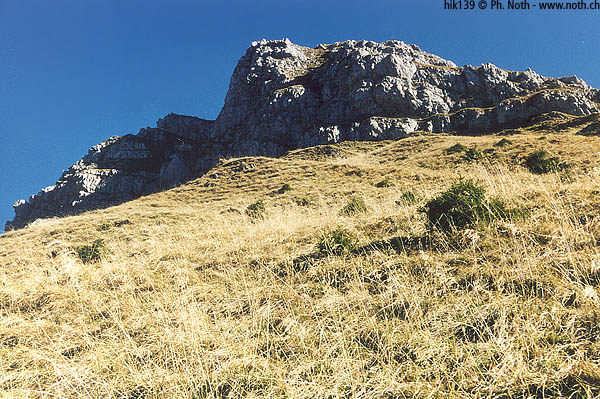
At Salzmatt, where the Kaiseregg presents its north face, I realised that this mountain was less debonair than I had imagined. The memories that I had kept from my skiing days in my childhood were limited to a slope with a ski lift at the end. Concerning this ski lift, you will see the last pylon by following the grassy edge to the south. After 30 minutes, you abandon this ridge to start through the western side and get closer to the Col du Kaiseregg (Kaisereggpass, 2072m, 6798ft) which you can see above your head. The atmosphere becomes more severe. The path which has been perfectly well set up leaves the grassy slopes and zigzags through the rocks. Late in the season, this shady slope may present some remains of early morning frosts, and even ice.
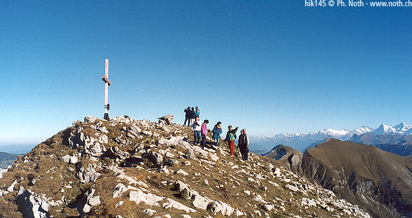
At the pass, the vast panorama opens on to the west and to the Bernese Oberland (Eiger, Jungfrau Blümlisalp). There are benches and often many more hikers. Count 1 hour since Salzmatt. In another 20 minutes you reach the top of the Kaiseregg through a path that leaves to the left of the col. The 360-degree view offers a contrast between the Plateau and the last foothills of the Alps, to the North-West (photo 2), with the high Bernese and Valais peaks, to the East and to the South (photo 1).
The return to Salzmatt takes 1 hour. A nice option is described in the guides Lonely Planet - Walking in Switzerland and Rother Wanderführer - Berner Oberland West: to make the crossing to the canton of Bern and the village of Boltigen.