The book can be ordered online at the Slatkine website or bought in any good bookstore of French-speaking Switzerland
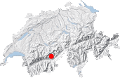
If one was to try and find the most remote place in all Switzerland, the Baltschieder hut might well turn out to be top of the list. To access this hut you have to adventure into the heart of the Bernese Alps and climb relentlessly for 5-6 hours along a path that provides no alternatives and no alpine farms where to stop for a break. In other mountains around the world this might be common place, but in the Swiss Alps it's rather rare. Because of the length of the climb to the hut, the latter should not necessarily be the aim of the day. The idea is more to enjoy yourself in a preserved setting surrounded by high mountains and diverse landscapes. There is no hassle about finding your way so why not try meditative walking? The path to follow is simple with no forks. And the icing on the cake is the paths both in and out of the Baltschiedertal valley which both follow two of the most beautiful bisses (irrigation channels) in Switzerland.
I therefore had high expectations when starting the walk. Unfortunately they were not all fulfilled and in the end I only awarded this route an "aloneness" score of 2 out of 5. Based on my own experience and that of other walkers, this route does not always provide the aloneness hoped for. The bisses leading in and out of the Baltschiedertal valley, the Gorperi and Undra bises, are both interesting and fairly easy, and perhaps attract more visitors than those of the Gredetschtal and Seetal valleys.
Climbing to the hut and back in one day is therefore possible but not particularly reasonable. Even if you start from the closest possible place in Choruderri, it is still 5½ hours of relentless climbing, not to mention the walk back. The starting point is obvious: a bend in the road (for which authorization is required) at an altitude of 1259 m. You can obtain the pass for the road in one of the restaurants/hotels in Ausserberg. In Choruderri, you will find an information board on the Alpjuhorn nature reserve as well a warning about the potential risks of walking the Niwärch bisse path. The official footpath sign gives a walking time of 5 hours and 5 minutes for the Baltschieder hut. This is less than expected but you will soon feel disillusioned...
The bisse de Niwärch soon appears and things start to get exciting. It has the reputation of being a very vertiginous bisse. You will therefore not be surprised when, after a few minutes and a small religious monument, impressive portions follow one after another with hollowed-out tree trunks (bazots) overlaid with planks for people to walk on and channels dug out of the cliff. The bisse is magnificent and the boldness of the bisse builders is quite astonishing. Careful not to ponder on it too much and keep your eyes on your feet! Most of the vertiginous portions are equipped with ropes or cables, but not all of them! However, the planks and walkways are by no means the most treacherous parts. The worst parts are actually the small overhanging walls along the side of the bisse along which the path runs. If you find the Nirwärch bisse path too daunting then it is best to turn back. You can continue up the road for a few minutes and then take the tunnel into the valley. In this case, follow directions for Stolleneingang and make sure you have a lamp handy because the tunnel is not lit.
Only parts of the bisse contain water, including some portions made out of bazots (hollowed-out trees). The ground levels out little by little and you will soon reach a chalet and barn called Ze Steinu [1296 m, 45 min]. This is where you get disillusioned: the sign for the Baltschieder hut here indicates 5 hours, i.e. only 5 minutes less than when you started off ¾ hour ago! Upper Valais maths can sometimes be unfathomable … as is the language. The path then climbs up about 50 meters, before becoming less strenuous again. At Eiiltini [1476 m, 1h20], you will find several crosses and a chapel near to several mostly wooden houses. It looks like some kind of trappers' camp. A pretty little bridge then leads you over the torrent on to its left bank. The further you walk into the valley and the wilder the scenery gets. The path follows the stream closely to avoid avalanche snow cones and you will appreciate having trousers on as you push through the stinging nettles that border the path.
Chiemattu is a pretty plateau in the middle of which lies a large rectangular boulder and marks a turn in the valley. A small shelter is scarcely visible, nested under a large rock. The sharp craggy peak at the end of the valley (visible from the end of the bisse path) is the Stockhorn. The path now climbs up grassy slopes to pass around the right side of this peak that towers above you at an altitude of 3200 m. The first 300 meters of the strenuous climb will take you from 1600 m to the Martischipfa bridge at 1950 m [1940 m, 3 h]. Across the bridge, the second part of the climb awaits you in the alders. A rest is generally welcome at the Hohbitzu chapel [2200m, 3h45].
The scenery now consists of glaciers and rocks. The quiet stream crossed at Chiemattu is here quite different and crashes down a gorge gouged out by the glaciers. On the opposite side of the valley, a path is clearly visible leading up to former mines.
The path leads into the flat bottom of the upper Baltschieder valley where a maze of glacial streams lies. All around you tower three- and four-thousanders: Stockhorn, Bietschhorn, Jägihorn. Wooden bridges, some of which look temporary, help you cross again to the left bank of the Baltschiederbach [approx. 2275 m, 4 h]. The number of bridges and their positions depend on the amount of water. On a south facing terrace under the Jägihorn, a mountain hut taunts walkers, so close and yet so far: another 500-m climb meaning about 1½ hours more. I decided to make it a day on the moraine, a storm was threatening and having to sit one out in a place like this did not appeal to me.
The way back down is the same as on the way up. If you feel tired before reaching the Niwärch bisse path, it's better to use the tunnel rather than risk slipping along the bisse.


This hike is featured in the book
Randonnées pour Grizzlys
Alpes valaisannes
published in 2013 by the editor Slatkine.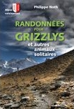
The book can be ordered online at the Slatkine website or bought in any good bookstore of French-speaking Switzerland