In short:
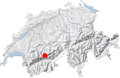
- Starting point: Crêta d’Asse (1739 m) or L’Aminona, caves de Colombire
- Total duration: 6 ½ hours
- Difficulty: T2 - Mountain Hikes
- KMZ file for Google Earth
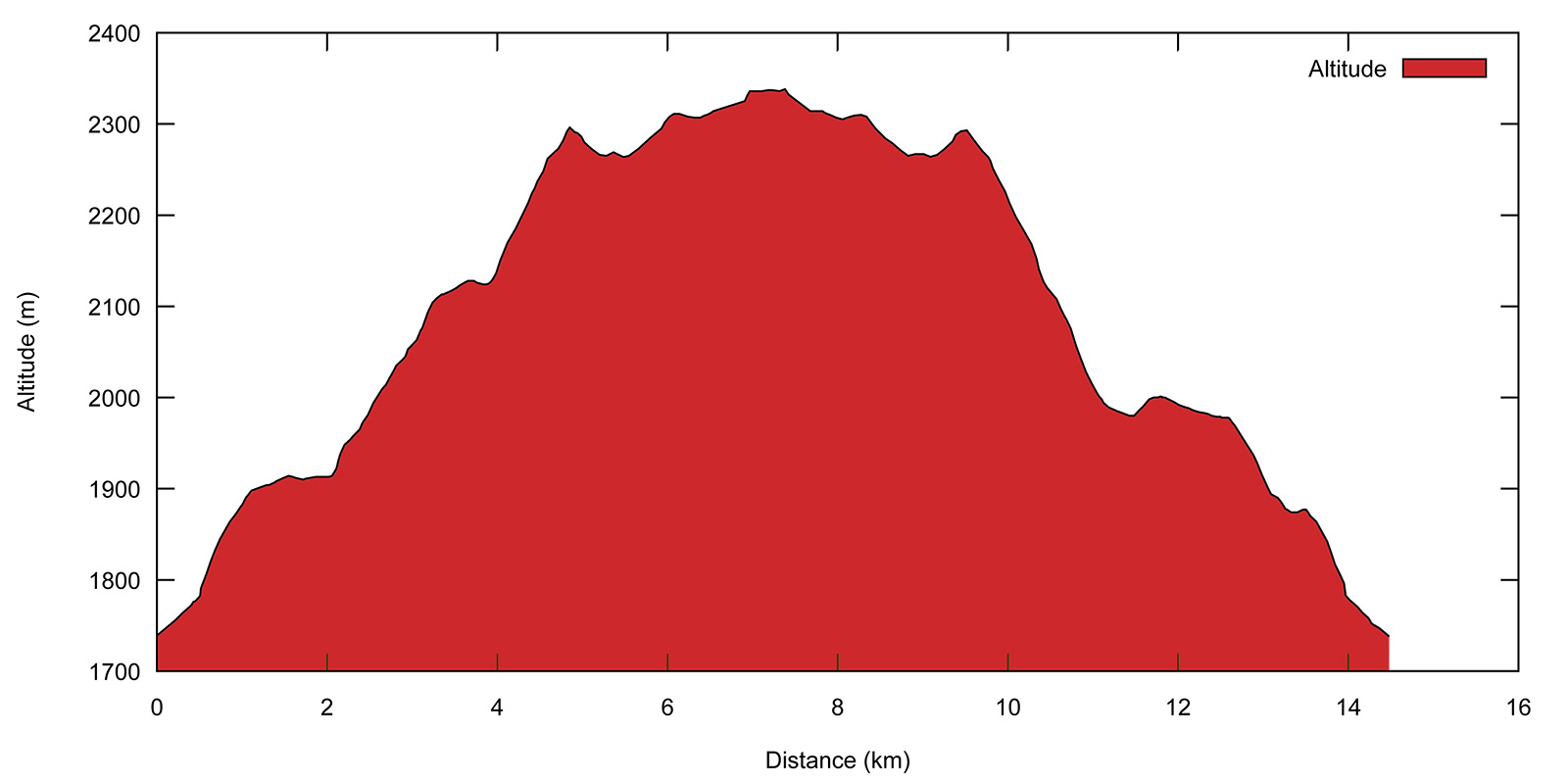
- Profile:

- Aloneness index:

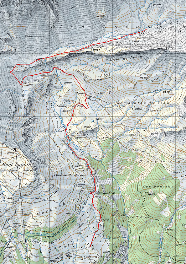
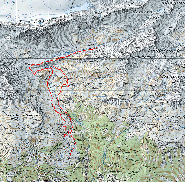
Maps:
Links (click on flag):
Les Outannes, Creux de la Tièche, bisse de Tsittoret
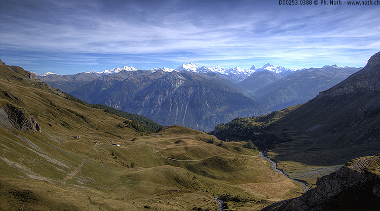
Walkers who tend to find some of the routes in this guide either technically too challenging or simply too long should be delighted with this walk in the Cirque de Faverges. This time there is no circuit to complete, no pass that needs reaching or mountain hut to visit. You can simply decide whether you keep going or not depending on how you get on and what you feel like. The only aim of the day is to reach the Outannes valley to enjoy the incredibly peaceful setting - and, if you start from L'Aminona, the walk to reach it is neither particularly hard nor particularly long.
The beautiful Outannes valley stretches out below Plaine Morte (dead plain) as would a hammock slung between Mont Bonvin and the Schwarzhorn. Comparing the valley with a hammock is quite appropriate due the relaxing and restful nature of the place. As described here you can stroll up the valley for about an hour before turning back down. But you are entirely free to take more time to explore or shorten your trip. Making it to the summit of the Schwarzhorn does not however ensure a greater level of solitude, since many attempt its ascent via its northern slopes and the Lämmerenhütte.
The walk starts near the cable car station in the village of L'Aminona, another village spoiled by ski tourism. If you come by car, take the road to the right towards Les Mayens, and then right again towards Cave du Scex. A few parking spaces can be found near the Crêta d'Asse chapel (before the barrier). You can also start the walk from Les Caves de Colombire or Ploumachit. The walking times provided hereafter are based on starting from the car park at Crêta d'Asse.
Whether you start from Crêta d'Asse, L'Aminona or Ploumachit, the first part of the walk involves reaching the alpine refreshment bar at Cave du Scex [1878 m, 30-60 minutes]. At this point the bisse du Tsittoret (a bisse is an ancient alpine irrigation canal) flows down freely for several meters and forms a small waterfall. Steps dug out in the mountain side take you quickly up under the trees until you stand next to the bisse. With the increasing interest in ancient traditions and ways of life, seeing a real mountain bisse is the goal of several popular local walks. Consequently, this part of the walk can be practically crowded out in the summer and at weekends. Only later in the day will we loners feel more at home. Be ready to grit your teeth and try to take in the romantic setting as you walk along the bank.
Stay on the path next to the bisse until you reach its source in the Tièche stream. The bisse dates from the 15th century. It transports substantial amounts of water, and remains operational until the end of September when many other bisses have dried up. In July, the banks of this bisse harbor an abundance of mountain flowers.
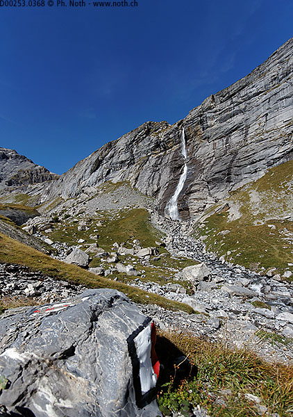
The flat portion of the bisse ends at a waterfall on the Tièche stream. To the right side of the stream, climb the high steps up the side of the waterfall using the rope if needed. You will in fact be climbing up between two waterfalls: the one on the left is collected and flows down the bisse de Tsittoret, whereas the water to the right continues on freely down the valley and forms the Raspille stream lower down.
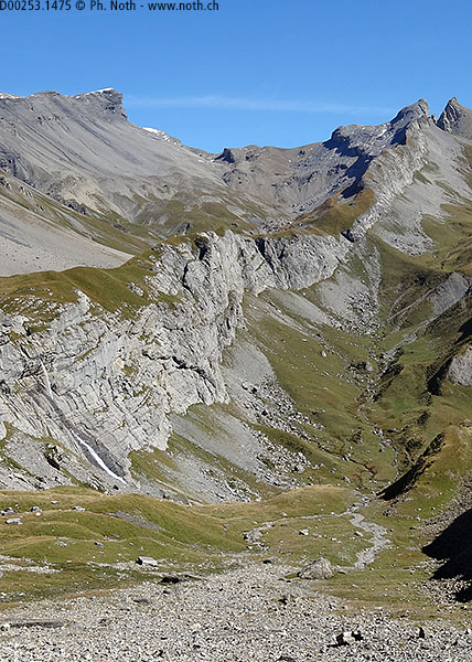
There are no signs for the Outannes valley at the Tsittoret water inlet [1950 m, 1h], which is actually probably a good omen for us loners. You can now choose between two options: either staying on the western slopes, in which case you should follow signs to Petit Mont Bonvin, or heading towards Montagne du Plan for a less direct itinerary to the east. Opt for the easier second option, cross the footbridge over the catchment pool and take the pasture track up to Montagne du Plan [2075 m, 1h15]. From here the Nusey ridge is clearly visible, a long stretch of cliffs and rocks behind which hides the secret Outannes valley. The valley lies so inconspicuously that one would not imagine that a trail runs its entire length. Even from the top of the nearby Trubelstock or the Col de la Roue, it was impossible to tell whether the Outannes valley would be a good destination for a loner walk.
As seen from here, the path heads to the far left of the Nusey ridge, a place called Creux de la Tièche, the only possible way into the valley. First, head up towards the impressive waterfall that has been dominating the landscape for some time already. Looking behind you as you walk, admire the magnificent view towards the Dent Blanche, Matterhorn, Aiguilles d'Arolla and Mischabel. You'll be able to appreciate the sight in more detail this afternoon on the way down.
At the Montagne du Plan farm, leave the track and path towards the Trubelstock and take the path signposted Petit Mont Bonvin. The path climbs gently until you reach the bottom of the waterfall [2075 m, 1h45], a great place for a rest. After the waterfall, carry on towards the west, up a kind of ramp that provides access to the next level and down which flows a tiny stream. The closer you get to Mont Bonvin and the stonier the ground becomes. On the upper part of the ramp the path heads slightly leftwards before turning to the right. In this last part of the climb, you will look straight along the entire Nusey ridge. Here, a signpost provides information on what lies ahead [approx. 2300 m, 2h15]. For the first time, the Outannes valley is actually mentioned, just next to the Schwarzhorn pass and the Lämmerenhütte. Finding a well-trodden path with red and white markings in this secluded valley was quite a relief. Surprisingly, it is little mentioned on walking maps or guides - which explains its relative isolation. Many walking guides list the Bisse de Tsittoret as a favorite trip out, but none mention Les Outannes.
The idea of continuing on to the Schwarzhorn pass is appealing, apparently a pretty lake lies just below it, but that would mean a further 3-hour climb from here. The Outannes valley starts by a slight descent. The path runs along the southern side of the valley, as far away as possible from potential rockfall from the Faverges ridge. Beyond the Faverges ridge lies a vast expanse of ice, the Plaine Morte glacier, which is completely invisible from here.
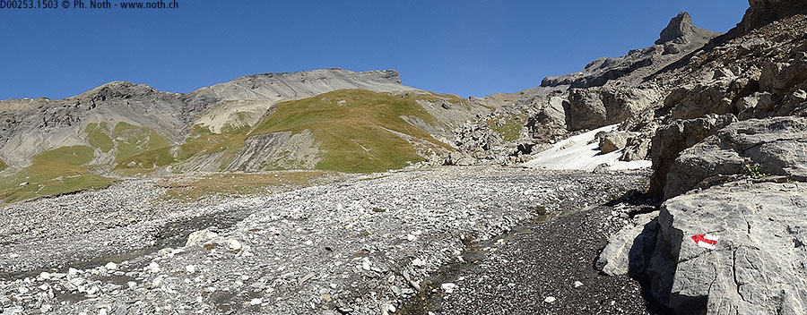
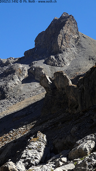
You will soon come across the Tièche stream again. To cross it (once again), use the small natural-looking arch held together with a dash of concrete. The bridge crosses the stream at the very place where it turns south and plunges down over the cliffs. It is the same waterfall that you admired from below a little earlier on. In front of you, you can see the alignment of the Nusey ridge leading up to the summit of the Nuseyhorn, and to its left the Trubelstock. As you get closer the Nuseyhorn seems all the more steep and craggy, whereas the Trubelstock seems flatter and more welcoming. The ascent route to climb the Trubelstock, graded T3, rises up and crosses the Nusey ridge before running along the craggy southern slopes under the summit of the Nuseyhorn. A bold route that you can see from the Outannes valley.
Blocks of rock and boulders are starting to make progression more difficult and a quick peek at the map shows that there are more and more as the path climbs up the valley. This walk ends just below the Nuseyhorn here in the Outannes valley at the point where the path to the Schwarzgrat gets steeper [2350 m, 3h30]. The way back down to the bottom of the waterfall is the same as on the way up. From there, to take a different but more direct route, follow the signs to Tièche to the right. There are a lot of different places called Tièche around these parts. Just know that 'Tièche' on the signposts invariably stands for the place where the water is collected for the bisse.
After a short portion where the ropes provided are useful because the rocks above the torrent are steep and slippery, the path widens and leads down across the Tièche grasslands. When the path joins up with the alpine track, follow on up towards the Cabane de la Tièche and Merdechon. Of course, you can also go back down towards and along the bisse via the path followed this morning, but the thought of stopping off at an alpine restaurant open round the clock is appealing. You can finish the walk by either sticking to the road (which might prove safer after dark) or taking one of the many shortcuts that will take you back to the starting point. As described here, the descent takes about 2h30 and the whole walk about 6 hours. A shorter version of this walk stopping at the top of the Tièche waterfall would take about 4 hours, without breaks.


This hike is featured in the book
Randonnées pour Grizzlys
Alpes valaisannes
published in 2013 by the editor Slatkine.
The book can be ordered online at the Slatkine website or bought in any good bookstore of French-speaking Switzerland