In short:
- Starting point: Fiesch-Eggishorn cable car, upper station
- Total duration: 5-6 hours
- Difficulty: T2 - Mountain Hikes
- KMZ file for Google Earth
- Profile (roundtrip):

- Aloneness index:
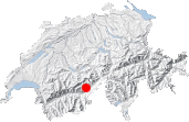
Maps:
Links (click on flag):
 Report and pictures on Randomandie.ch.
Eggishorn, Märjelesee, Aletschgletscher
Although I much prefer the calmer parts of the Alps, I couldn't deliberately stay away from the Aletsch glacier any longer. On the way back from the Tessin, I stopped off in the village Fiesch to do this "panoramic" circuit, a well merited description in such an environment of high summits and great glaciers.
A quick glance at the map and you'll realise how the region is abundant with paths and cable-car links. The tourists just have to be effortlessly motored up to admire the view over the longest glacier in the Alps. Among the many possible options, I set my sights on a circuit around the Eggishorn. This circuit is of a reasonable length and climb and can be either shortened or lengthened by using various links between the "glacier side" and the villages (Riederalp and Bettmeralp) such as those at Bettmerhorn, Hohbalm and Biel. I chose the latter.
In Fiesch, it's best to take the cable-car to the upper station - the Eggishorn station. At the intermediary Fiescheralp station the paths look less enticing (long tunnel towards Märjelesee). The cable-car takes you right up onto the ridge at 2869 m (9413ft) from where the view over the Aletsch glacier is breathtaking. Most of the people who travelled up with me are going to make the most of it either by heading up to the summit of the Eggishorn to the right, or follow the UNESCO World Heritage path (UNESCO Höhenweg) towards Bettmerhorn. As far as I'm concerned, I find it hard to cope with so many people in such a limited area so I head off straight away on the first leg of the walk towards Märjele. The path consists of a steep 250-metre descent with hairpins until it meets a fork, at an altitude of 2623 m according to the signpost, or 2625 m according to the Swiss national map. But let's not bicker over 2 metres!
By heading down this western side of the Eggishorn we loose the view towards the Aletsch glacier (but we'll have it back in about 45 minutes). Another great glacier, the Fieschergletscher, shows up to the north-west and compensates the loss. It should be noted that the route towards the Märjele lake appears in green on a brochure that can be found in the Fiesch tourist office called "From Eggishorn to water". At the previously mentioned fork, just below a great mound of boulders, follow indications for "Tälligrat, Märjela, Gletscherstube". The path heads northwards and runs just below this mineral chaos, before getting much easier across grassland and then even climbing a little up to Tälligrat (45 min, signpost).
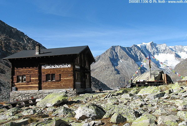
As its name implies, Tälligrat is a ridge, the west ridge of the Eggishorn. For here we can see the Aletschgletscher again, but only a tiny part of its enormous mass is visible through the Märjelesee gap, the next place we're aiming for. The descent from Tälligrat to Gletschertube is easy (1 hour). Here you'll find a chalet/restaurant near to the Vordersee dam lake and the glacier so it inevitably attracts a great deal of people. Among these, you'll meet the hikers who took the tunnel under the Tälligrat.
After a break, we approach the Märjelesee. Alas! I know that the glacier lake is not going to look anything like the pictures I saw of it in books when I was a child. The glacier's retreat is to be blamed for this. Only a 100 years back, even 50 years back perhaps, this was our own miniature Swiss "Jökulsarlon" in which floated the blocks of ice that broke off the Aletschgletscher.
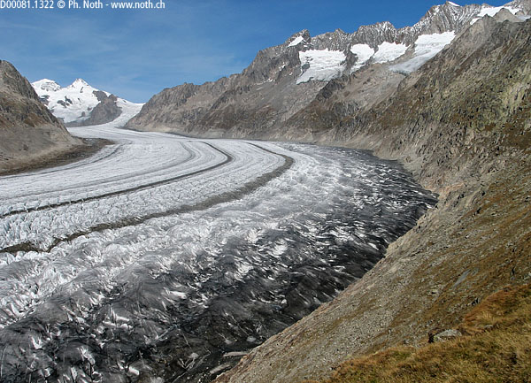
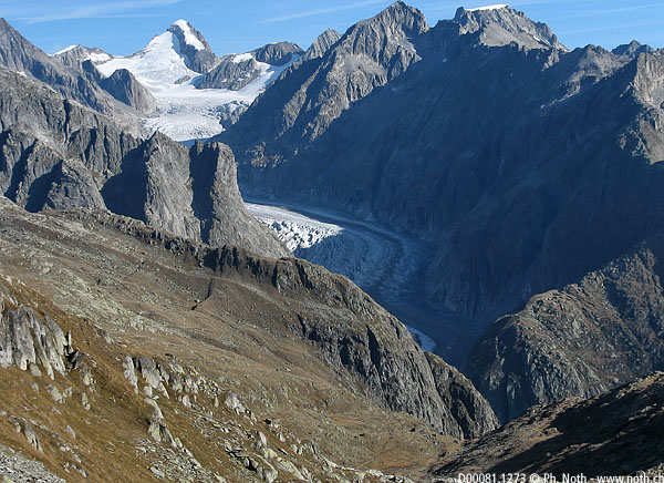
From here continue on to the left (follow "Roti Chumme, 30 min"). At the 2347 waypoint, the path crosses a few slabs on the north-west ridge of the Eggishorn and the passage is too narrow for the flow of walkers. Wait a few minutes until it's your turn to get by. Soon we'll need traffic lights up here! From here to Roti Chumme and Biel, the walk is easy and follows the Aletschgletscher for several kilometres. The Fiescherhörner glacier further upstream (photo 3) and the Fusshörner glacier on the other side are sad in comparison, cowering on the mountainside. At the Roti Chumme junction (2½ h), the upper path goes to Bettmergrat. Continue on towards Biel and Bettmeralp. A series of gentle ups and downs keeps the us at an altitude between 2200 m and 2400 m. When the weather is good the Matterhorn, Monte Rosa and Weisshorn stand out to the south-west.
)
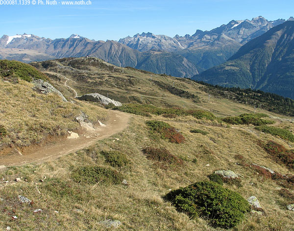
Near Biel (3 h), the path switches onto the other side of the mountain. From here on it's not easy to describe the route I took - there are just too many possibilities in all directions. I had to get my map out several times even though I knew which general direction I should head for. Basically, don't go down to Bettmeralp and its lake but instead cross the alpine meadows towards Kühboden. The place you're heading for is Fiescheralp which is also called Chiebode ("Kühboden" in the local dialect) on the map and some signposts. If like me you end up in Furrihütte, you'll soon find a road. It took me 5½ hours in all to reach the houses at Kühboden and Fiescheralp including an hour-long break. The final leg is effortless: take the cable-car back down.

