In short:
- Starting point: Champex TCH La Breya (1492 m) or Relais d’Arpette (1627 m)
- Total duration: 5-6 hours
- Difficulty: T3 - Challenging Mountain Hikes
- KMZ file for Google Earth
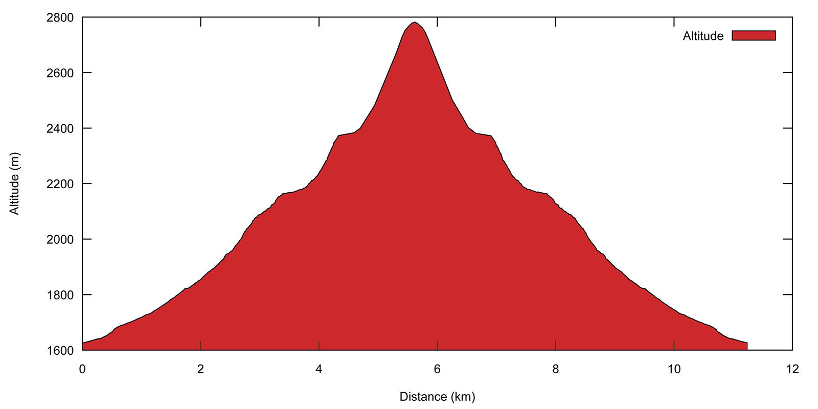
- Profile:
- Aloneness index:

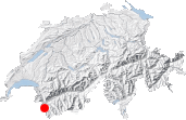
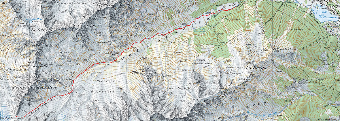
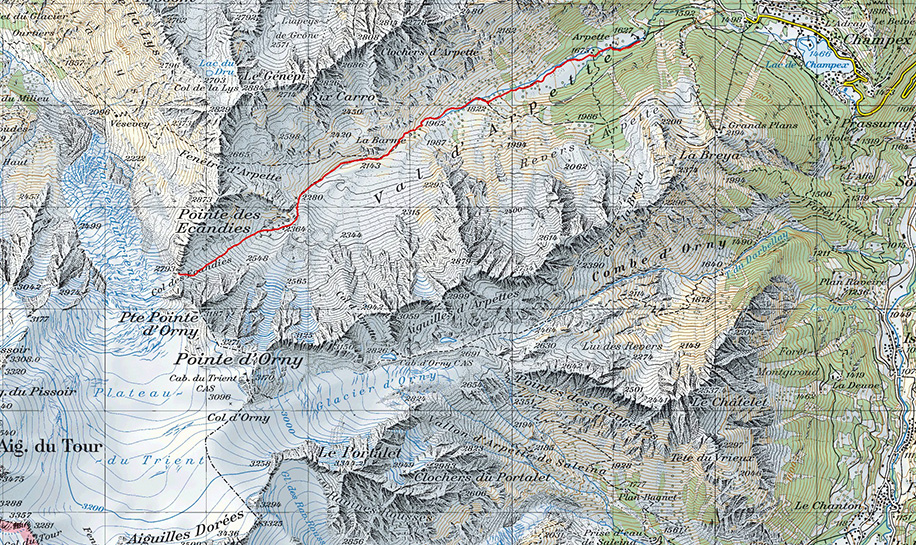
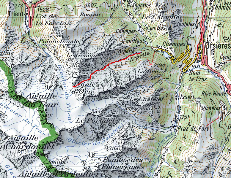
Maps:
Links (click on flag):
Col des Ecandies
When setting out from Champex, most hikers trekking around the Mont Blanc on the Tour du Mont Blanc (TMB) circuit head up the Arpette valley towards the Fenêtre d'Arpette pass. But why not visit a more remote pass away from the main flow of walkers?
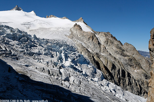
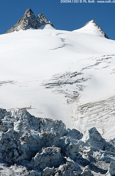
Although the two passes are only a kilometer away, they seems worlds apart. Both look down over the Trient glacier and provide amazing views over the colossal masses of moving ice. But the Col des Ecandies lies further upstream the glacier, level with its most spectacular portion, the icefall (séracs in French). This is the steepest portion of the glacier where the ice breaks up and is pushed up to form giant blocks. The Trient icefall is not quite up to Everest icefall standards, but it's definitely worth coming to see!
There being no way down the western side of the Col des Ecandies, at least for normal hikers, few people venture up here. The reward is complete tranquility. This is further evidenced by the difficulty of finding any information about climbing this pass in the summer time. Practically all Internet hits relate to skiing down from the pass in the winter or spring time. In the summer, visitors to the pass are mostly mountaineers aiming for the Ecandies ridge traverse and its mythical "saut de l'ange" (angel's jump).
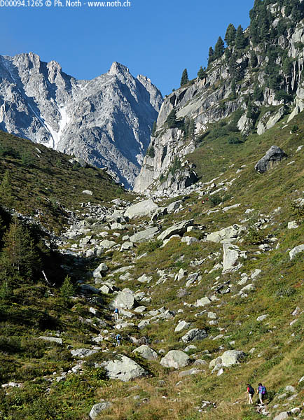
The starting point of this walk is very convenient and easy to find as you can start either from the ski lift car park in Champex or the Relais d'Arpette restaurant/hotel. Past the restaurant, the path heads up the Arpette valley, which is actually nearly flat at this point, towards the Pointe d'Orny, the Pointe des Ecandies and the Genepi peaks. The smooth, flat stones that pave the way make you feel as if you are walking an ancient Roman way.
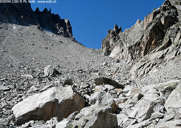
Continue on the track past two successive junctions signposted for Col de la Breya [walking times respectively of 30 min and 1 h]. The track comes to an end at the second junction and turns into a pretty mountain path following a small stream between slender alder trees and other bushes. Suddenly the path gets steeper and the climb harder as it squeezes between the ridge down from the Tête d'Arpette and the La Barme rocky outcrop. The natural stone steps the path follows at this point are tiring for the legs. When the path flattens out again the Pierrier d'Arpette, a vast expanse of rock and stone fall, lies to your left. A great many boulders have rolled down from above and come to a stop on this small flattish area. Up above, the stone wall under the Pointe des Ecandies overlooks the landscape.
At the junction between paths for Ecandies and Arpette [2143 m, 1h45], leave the main path to the Fenêtre d'Arpette without remorse and take the smaller trail to the left. The way is marked out with red paint on rocks. The path remains flat for the next 10 minutes, and then some serious uphill climbing starts and you will have risen from 2200 m to 2400 m in no time at all.
After 2½ hours walking, you will enter a combe consisting of nothing but rock: the Combe des Ecandies. The last 300-meter ascent to reach the pass climbs over chaotic ground: a bedlam of boulders, stones and moraine debris left by the glacier. Nothing grows here. Too steep, too much regular rock fall from the Petite Pointe d'Orny and the Pointe des Ecandies, the peaks surrounding the pass. It is not always easy to see where the path lies over this rocky ground so look out for cairns and red marks, and indeed, the last portion of the way is not actually printed on the 1:25000 Swiss map. However there is no doubt about it, the pass is clearly visible above: a rounded opening between jagged peaks. The best trail to follow lies on the left side up the former moraine. Nevertheless, when patches of snow still cover this area, it might be better to opt for a route more to the right. I climbed the pass in September when the summer sun had got rid of the last of the snow.
When you finally reach the pass [2793 m, 3h45] be ready for an outstanding view over the Trient glacier, its icefall and upper plateau. You'll only be able to see a small portion of the latter. For a more extensive view, consider hiking the more frequently run route up to the Cabane du Trient. The return route follows the exact same paths as on the way up [approx. 2h30 back to the starting point].


This hike is featured in the book
Randonnées pour Grizzlys
Alpes valaisannes
published in 2013 by the editor Slatkine.
The book can be ordered online at the Slatkine website or bought in any good bookstore of French-speaking Switzerland