In short:
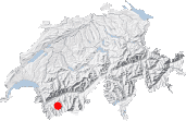
- Starting point: Fionnay
- Total duration: 7 hours
- Difficulty: T3 - Challenging Mountain Hikes
- KMZ file for Google Earth
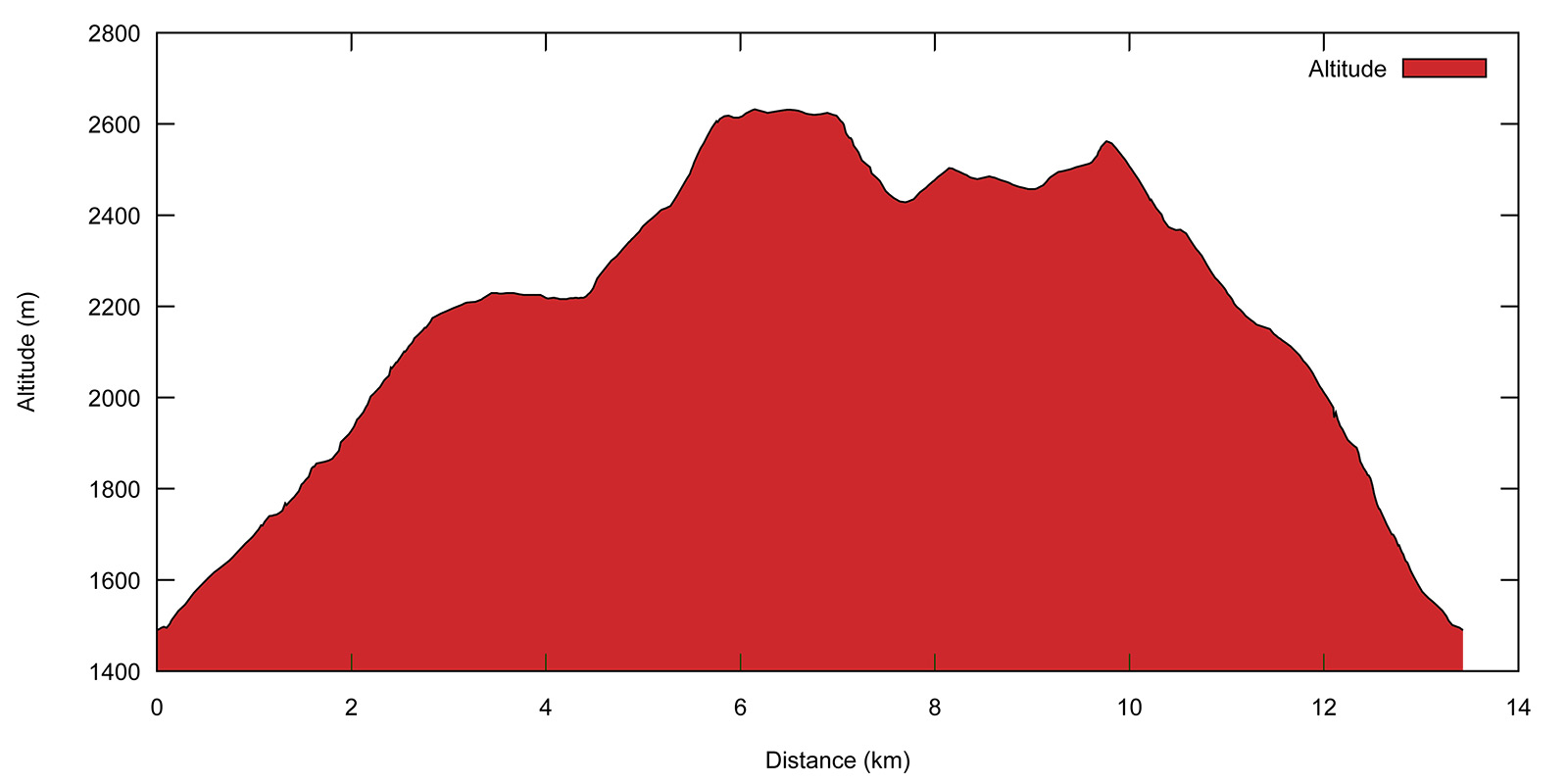
- Profile:
- Aloneness index:

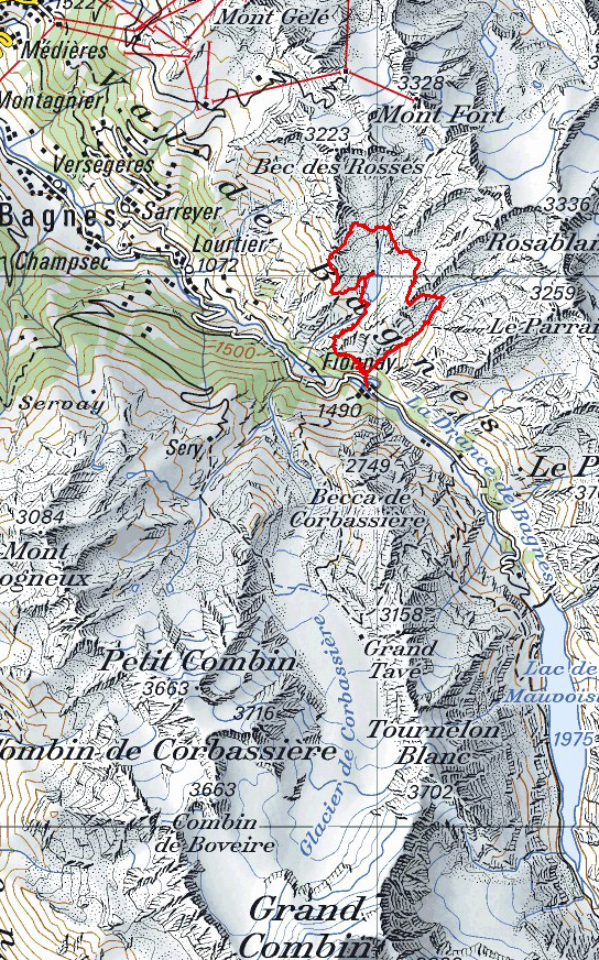
Maps:
Links (click on flag):
 Louvie - Le Dâ - Le Crêt, roundtrip above Fionnay (Randalp).
Cabane de Louvie, Lac de Louvie, Col Termin, Col du Bec d'Aigle
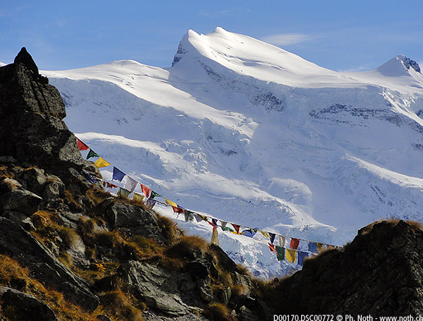
There is no lack of high altitude alpine hikes in the triangle formed between the Mont Fort, Grand Combin and Mont Collon peaks, a region called the upper Bagnes valley. Some venture along or above the Corbassière glacier or climb the slopes of the Grand Combin, whereas others follow the banks of the Lac de Mauvoisin. But the calmest parts in this area are probably to the east of Fionnay and Lourtier, close to the Lac de Louvie. Via high mountain passes, this hike will take around the Louvie glacial lake that lies in a depression scoured out by a long gone glacier. Contrary to Col Termin that is a popular pass, the col du Bec d'Aigle is a much quieter pass, especially when approached from the north via the Combe de Momin. You should also be aware that this itinerary includes some fairly vertiginous sections where the path crosses very steep open slopes. It is perhaps the lack of trees that makes them all the more impressive.
The Louvie area is part of the Mont Pleureur nature reserve. You are likely to meet mountain ibex somewhere along the way and perhaps spot chamois. "Meet" and "spot" are the right terms here and cannot be inverted between the two species, the first being quite easy to approach and the latter fleeing before you get anywhere near. You are therefore much more likely to live a close encounter with an ibex than a chamois.
The walk starts in Fionnay, near the balancing reservoirs that store the water from the Grande Dixence dam used to make hydroelectricity. Near to the large hydroelectricity plant building, a sign for the Cabane de Louvie can be found next to the official footpath signs: Cabane de Louvie, 2250m, restauration, boissons, dortoirs.

Follow this path. At the first junction [1554 m, 15 min], ignore the path to the right signposted to Le Dâ, you will come back this way later on. Stay on the path to Louvie. It continues up the steep slopes of the La Heu meadows along hairpin turns that head globally leftwards. The last hairpins are tighter as you get nearer to the rocky outcrop (altitude 1859 m) where the path changes direction. Long chains have been added along the ledge to help walkers on this portion. They sometimes seem unnecessary but if they can reassure beginners and help them make it to the Cirque de Louvie, then so much the better. After this rocky portion, the path gradually takes a right turn and heads north-eastwards. Walking is now much easier as you get closer to the lake. If you set out in the morning sun, you will now be walking in the shade of La Rogneuse, the peak up above to your right.
As you cross the stream that flows out of the lake you will see a sign welcoming you to the Louvie pasture lands and lake. They explain how the various old mountain barns and sheds found in the meadows here were originally built and restored. You will be walking past two of these on this circuit. The Cabane de Louvie [2250 m, 2 h] lies a little further on, slightly raised above the lake with a great view over both the latter and the Combins range to the south. It is not a Swiss Alpine Club (CAS) mountain hut but is privately owned and welcomes hikers for a night (with prior reservation) and meals when open.

The next portion of the walk will take you to the first pass, Col Termin. Follow the path along the bank of the lake, but make sure you visit the Écurie de Louvie (Louvie stables) built in 1814 before starting the climb to the pass [2215 m, 2h15]. Brown signposts clearly show the way to the old building, only an extra 5 minutes away.
After the visit, walk back to the junction and head up the path towards the Termin pass and the Cabane du Mont Fort. The first part of the climb through the Lui Fay pasture is pleasant, with the view getting increasingly spectacular at each step and prompting you to climb ever higher. Altius, fortius, (higher, stronger) says the motto, but let's disregard citius (faster) here, we're not at the Olympic Games! Take plenty of time to contemplate the view, especially now that with the height gained new landscape features can be seen, such as the Corbassière glacier and the Mauvoisin dam.
At an altitude of 2431 m, you will cross a ridge and the Lac de Louvie disappears out of sight. The upward climb on the western slopes just under the Têtes de Louvie ridge becomes both more strenuous and vertiginous. The path winds its way across the steep grassy banks on the Bagnes valley side rather than the rocky outcrops on the Louvie side. From here on, the itinerary deserves to be graded T3 on the Swiss Alpine Club scale, whereas up to now T2 was acceptable. It is only when you reach the Termin pass that you will see the lake again [2648 m, 3h30]. Unusually timid mountain ibex ran away among the rocks as I reached the pass. They can't have read the signs at the lake! Didn't anyone tell them they live in a nature reserve?

Col Termin sees quite a number of hikers. It is on the routes of the Tour du Val de Bagnes race, the Sentier des Chamois (Chamois trail) and itinerary No. 6 of Swiss national parks (Alpine passes trail, from Grisons to the Valais Alps in 34 days). It is perhaps therefore not the best of places for an undisturbed siesta, and there isn't much room to lie down anyway. The second pass of this walk, the Col du Bec d'Aigle, is much quieter. You can see it from here already, looking out in a straight line over the center of the lake, more or less at the same altitude as the Termin pass.
Leave the path that leads down from the pass towards Lourtier and set out in the opposite direction towards Le Dâ, signposted as being 2 hours away. The path leads down above the lake across again very steep slopes. In fact, you will not lose much ground during the first 15 minutes or so, although the path drops here and there but also climbs back up in places. It is only further on that it plunges down not to the lake but to a flatter area called Plan da Gole. Be careful not to follow signs to Col de Louvie and to take the downwards path.
When you reach Plan da Gole [2418 m, 4h15], continue on towards Le Dâ. Several carefully positioned stones in the marshy area before the stream feeding the lake help to keep your feet dry. Stream that you then cross before heading up the other side of the Louvie cirque. You will soon reach the Momin alpine pastures, the gentlest slopes and quietest portion of this "normal" route to the Col du Bec d'Aigle that lies further south. Shortly, large stones and then rocks hinder your progression, and even when the path starts to climb again, you have to wind your way between and over the rocks looking out carefully for the red and white markings. High up, just before the pass at an altitude of 2614 m, a path leads back down to the Lac de Louvie. A possible escape route if the Col du Bec d'Aigle is too vertiginous to your liking.
The pass will bring you a good and a bad surprise. The good part is that the end of the ascent gets much easier, with more grass and less unstable stones. The bad surprise is when you see where the path goes down on the other side. Quite intimidating! Special attention is required in the first part of the descent. But first, enjoy the view from the pass [2567 m, 5h15]. An old Swiss Alpine Club guide calls this narrow pass the Col du Chardon (Thistle pass) and also indicates that is known locally as the Basset de Severeu.
The pass takes you out of the Louvie cirque and into the wilder Dâ valley. The path leading down from the pass crosses a very steep slope and requires extra attention and steadiness. It first heads north and then east towards the bottom of the Dâ valley [2365 m, 5h45], where a stone building lies. Up to your left, another solitary pass, Tête de Sarshlau, is visible and its ascent is tempting. However, when planning this walk with the tool on the SwitzerlandMobility website, adding this third pass to the itinerary made it excessively long: 8 hours without counting pauses. It is therefore preferable to keep the Tête de Sarshlau for another outing, for example via the Vasevay pastures and stables.
Follow the path along the stream and valley bottom towards the Sovereu habitations. It is here, and not on the so-called Chamois Trail, that I sighted and managed to watch for some time one of these timid animals. It was late though and the mountains were as calm and peaceful as they get. Further on the valley narrows substantially and can seem rather gloomy when the sun has moved away. But the path, although steep, is easy and the end is near. At last the junction where you took a left in the morning appears, followed shortly by the car park or the Fionnay bus stop.


This hike is featured in the book
Randonnées pour Grizzlys
Alpes valaisannes
published in 2013 by the editor Slatkine.
The book can be ordered online at the Slatkine website or bought in any good bookstore of French-speaking Switzerland