In short:
- Starting point: Pramousse
- Total duration: 4 hours
- Difficulty: T2 - Mountain Hikes
- KMZ file for Google Earth
- Profile:

- Aloneness index:


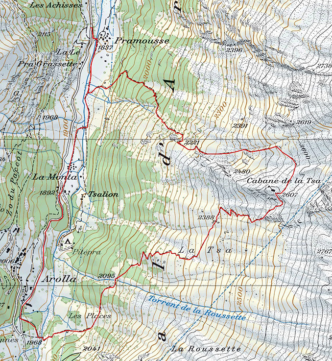
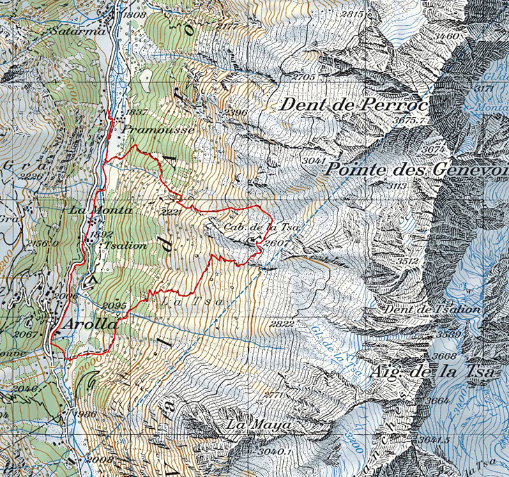
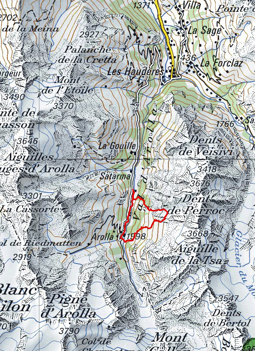
Maps:
Links (click on flag):
Cabane de la Tsa (par Pramousse)
You might wonder why this easily accessible, family-style mountain hut is described in this guide for loners? As mentioned in the title, it is because an unjustly disregarded itinerary that starts in Pramousse makes this walk unexpectedly interesting.
As the Buddhist saying reminds us: "The journey is the reward". Even if the endpoint of this walk is the Cabane de la Tsa, the real destination of the day is the wild combe between Pramousse and La Pointe des Genevois. If you start out in the morning, you will probably meet no-one at all, for three different reasons:
- as I am writing this report (Autumn 2012), no signs indicate the start of the climb south of Pramousse, as if it was deliberately kept secret,
- the 1:25,000 scale Swiss maps only show an intermittent path,
- the village of Arolla is the most logical and practical choice to start for the Cabane de la Tsa, especially for the tourists staying at the station.
All these reasons, as well as the lack of precise information, did make me think twice before actually attempting this itinerary. Sometimes it is only on-site that you know something will work out - and this was the case here. I had actually even planned a replacement itinerary (Col des Ignes, on the other side of the valley) in case I had to abandon half way up.

This description therefore covers the climb up to the mountain hut via this alternative route and the way down by the usual path to Arolla. Then the itinerary follows the Borgne d'Arolla river and then the road and a path to bring you back to Pramousse.
Pramousse is a pretty hamlet that lies below the road to Arolla. The walk starts at the bus stop where a sign gives a walking time of 2h20 for the Cabane de la Tsa. As you will soon see, this time is for the itinerary via Arolla, but you need to follow this path for about 10 minutes.
Follow down and over the bridge that crosses the Borgne d'Arolla, then follow the river to the right (south) as shown on the signpost. When the path crosses a small stream with another bridge and a footpath sign, leave the main path. The start of the alternative itinerary up to the Cabane de la Tsa is very close by but not at all indicated here. To find it, cross the field heading up and to the north east towards the edge of the forest. There you will find, either quickly if you are lucky or after looking around a while, a red pole as well as red markings on a rock [approx. 1840 m, 10 minutes]. A detailed map or using a GPS may help!
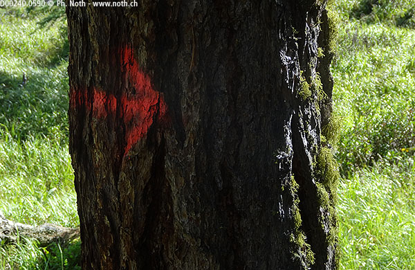
The path dives straight into the forest. A magnificent forest of pines and larches with a beautiful smell to it. The path is much better marked out than you would expect seeing how difficult it is to find it. The markings, which consist of dark red arrows and dots, are discrete but not difficult to follow. And as to finding your way, you have done the hardest part because the path now leads straight up to the mountain hut. No chance of getting lost now.
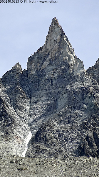
For those who take the time to rest and look out, breaks in the forest offer superb views out towards the Pigne d'Arolla and the Aiguilles Rouges range. If you have good eyesight or a pair of binoculars, you might be able to spot the Aiguilles Rouges mountain hut. Soon binoculars will also be needed to find the Aiguilles Rouges glacier due to its impressive rate of retreat over the last few years.
The climb up is sustained but without any real difficulties. The trees leave place little by little to alders and scattered rocks. As the path comes out of the forest it becomes somewhat easier and leads towards a rocky outcrop. Above you, the Aiguille de la Tsa is starting to come into view. You are now at an altitude of approximately 2300 m. Wide, fairly gentle hairpins lead up the left side of a quiet combe. It's an ideal place for a break. Take your time, the walk is short and easy and there is no need to rush. If you are looking for quiet, this is where you'll find it, not higher up. The mountain hut, when open, is a bustling, alive place where you will be welcome but not alone.
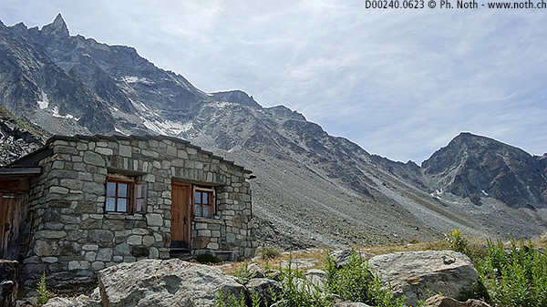
And the hut actually appears much faster than expected, sitting on a rocky outcrop to the right. "Sprawling" would actually fit better, the building being low and long, as if it was afraid of being uprooted by the wind and blown away.
It is only as you get nearer to the hut that the usual red and white markings appear to show you the way across the last portion of scree and rock. However the path remains easy and heads right to overcome this last obstacle, winding its way through the boulders. You should count 2¼ hours of walking for this first part of the walk.
Your time at the hut will be marked by the crashing noises made by invisible rock and ice slides. Further up the mountain side, below the summit, the small Tsa glacier struggles against gravity to survive. The glacier is not visible from the hut but you can make out the unsteady portion mountain side, probably fragilized as its permafrost weakens.
The way back via the usual path requires still less explanations. As it is a direct route, it is also very short. Here again there are no misleading junctions. After 45 minutes of easy descent, the path dives into the forest again. Arolla isn't very far off. In the Places clearing [1980 m, 1 h after leaving the hut], you might see the local Herens cows and you will definitely see an enormous boulder that is actually so big that it is drawn on the map. Cross the Borgne d'Arolla using the bridge and follow the path back up to the center of the village [1969 m, 1h15 after leaving the hut]. When I did this walk, the bridge had been carried away by the river and a detour had been set up.
For those who choose to catch a bus the walk ends here. You can wait for it while sitting at a cafe terrace and enjoying a glass of Valais white wine. For those who decide to keep going, an extra 30 minutes of gentle descent lies ahead. Follow the signs for "La Monta" until you get to the Aiguille de la Tza hotel, where you should take right down towards the river. After the last chalets and barns of the La Monta hamlet, a small bridge crosses the river. A little afterward you will meet up with the path from Pramousse that you came along on the way up [1h45 for the descent, 4h for the whole walk].


This hike is featured in the book
Randonnées pour Grizzlys
Alpes valaisannes
published in 2013 by the editor Slatkine.
The book can be ordered online at the Slatkine website or bought in any good bookstore of French-speaking Switzerland