In short:
- Starting point: Van-d'en-Haut, near Salvan
- Total duration: 8 hours
- Difficulty: T3 - Challenging Mountain Hikes
- KMZ file for Google Earth
- Profile (up & down):

- Aloneness index:

Maps:
- Extracts:
1:25'000 1:50'000 1:200'000 - Swisstopo shop:
1:50'000
272T
St Maurice
1:50'000
282T
Martigny
Links (click on flag):
 Notes on Auberge de Salanfe and the quality of its welcome, Guide des refuges de haute et moyenne montagne by Markus Jaton.
-

 Website of the Auberge de Salanfe (food and accomodation).
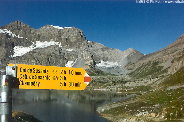
 - The Dents du Midi, with Haute Cime and Susanfe Hut. Taken from Dwight Peck's personal Web site.
Refuge des Dents du Midi, Lac de Salanfe
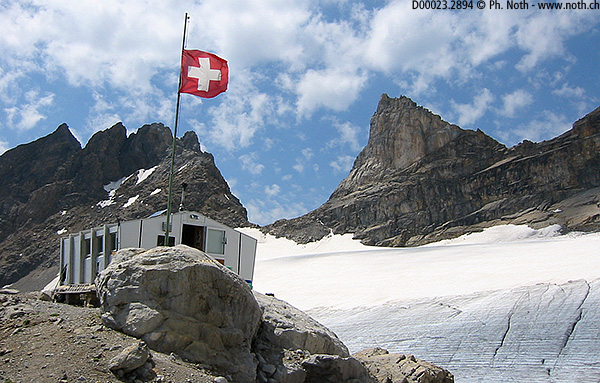
After the Haute Cime, Lac de Salanfe, Col de Susanfe, here is another itinerary that leads you to Lake Salanfe and then the splendid Dents du Midi mountain range. Our goal today is the refuge that goes by the same name (also called Refuge de Plan Névé, 2884, 9461ft).
When I did this itinerary in the summer of 2002, I still had in mind the unprotected and very solitary refuge that I'd known in 1996. Since that time, however, kind volunteers have been taking care of the refuge and the path that leads to it.
Though I've previously described the route to Salanfe on the page related to the Haute Cime, Lac de Salanfe, Col de Susanfe, I'd like to make an update.
First things first: it is no longer necessary to park your car at the Van d'en Haut camping grounds. Now you can cross the small bridge and find a place to park a little further on.
To cross the forest to get to Salanfe, you have 2 choices: a wide route suitable for motor vehicles but banned or a path. An improvised cardboard sign points this out. Farther on, where the 2 ways become one, another sign reads "Fontaine à Moïse" or "Escaliers" - once again, you have the choice between a route or a path. The route zigzags upwards and goes past a trickle of water coming from the rock wall - you guessed correctly: it's the Fontaine à Moïse ("Moses's Fountain"). As for the path, parts of it have iron steps to make your way along the cliffs easier.
45 min. later, you get your first look of the Salanfe Dam (barrage in French) and the white chapel perched on the ridge; 30 (less difficult) min. after that, you arrive at the Salanfe Inn. If you decide to take a break on the terrace, please give my regards to Fabienne.
One quick look toward the hut and you'll probably feel intimidated: the remainder of the way up (exactly 958m, 3143ft), once the snow has completely melted, looks like an unwelcoming huge slope of loose stone. But that one glance couldn't be more misleading: the path could barely be better - and that we owe to the new keepers and their friends!
From the inn, you immediately make your way upward on the lake's right side, where you'll often find cows grazing - in fact, you pass the back of a lengthy structure that's most likely a cowshed. An hour later, the altitude indicators reads 2121m (6958ft). If you're counting, don't be surprised when you find out that you've done only 200 meters (660 ft) elevation. Out of the blue, markers and cairns point out a detour: because the the new passage isn't well trodden yet, you have to hike on rather rough-going ground for a while. But as soon as you're back on the usual path, everything gets easier.

Past Combe des Orgières, on your right, it's all scree and rocks. For a moment, you can make out the cabane and its flag. It looks far off and high up; so high up that the slope gets steeper until the final elevation of 2884m (9462ft). Someone was raking the path! I was surprised by the care taken for a path not taken very often. The refuge isn't a passage, as are the Col de Susanfe and the Col d'Emaney. The person raking told me that the refuge now had a keeper.
The closer you get, the more clearly you see the flag. Though the day on which I took this hike again wasn't very bright, the look back at the Grand Combin and the Mont Blanc (partly hidden by the Tour Sallière) was unequaled. This view is almost exactly the same view that you get when you climb up to Haute Cime.
About 30 min. before you arrive at the refuge, the path reaches a moraine and the red and white markers tell you to bear left. In the past, you had to walk along the moraine all the way to the cabane; there are people who still do it that way. But I heed the advice and walk along the new trail, cross a flat firn, a field of boulders, another sloped firn, and then finally reach the latrines (!) and the Dents du Midi Refuge.
The Glacier de Plan Névé, the Dents du Midi, and the Col de la Dent Jaune make up the refuge's background. It takes 3 hours to find your way back down.

