In short:
- Starting point: Zermatt, Unterrothorn station
- Total duration: 3 hours (or more, depending of the options for the return)
- Difficulty: T2 - Mountain Hikes (but beware of the high altitude)
- KMZ file for Google Earth
- Profile (roundtrip):

- Aloneness index:

Maps:
Links (click on flag):
 Oberrothorn, by Ken Baldry. One of his pages of walks around Zermatt.
 The exact same tour, described on Christian Engl's website. With pictures and comments.
- Hike report on Hikr.org.
Oberrothorn
This 3415m (11204ft) peak can be easily climbed thanks to or due to, depending on your point of view, the Sunnegga/Unterrothorn ski lifts. A beautiful viewpoint, unfortunately cruelly spoilt by the ski slopes.

An American friend of mine described this outing to the Oberrothorn as "decadent" since walkers travel by the horrible Sunegga underground railway and then via two cable cars, the Blauherd and Unterrothorn cable cars, before putting one foot in front of the other on a path! You'll be at 3103m (10180ft) without having burnt a single calory!
From the Unterrohorn restaurant, walk eastwards down the gently sloped hummock on which the building stands (photo 1). From Furgg, the saddle-shaped area between the Oberrothorn and Unterrothorn (reached after approx. 15 minutes), the path starts to climb again. Here you'll leave the ski slopes and at last see some grass and flowers. Make the most of it because it doesn't last long since the path starts heading up tight hairpins on the southern side of the Oberrothorn where no vegetation grows because of the altitude, erosion or for both reasons.
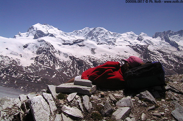
At over 3000m of altitude it can snow here all year round. When we did this walk, we came across our first patches of snow at about 3230m but these didn't cause us any serious problems. This climb up the south facing slopes provides greats views towards the Mont Rose range as well as out over two less well known "four thousanders": the Rimpfischorn and the Strahlhorn. Once you have reached the top, the panorama is even better and includes the Matterhorn, the Dent d'Hérens, the Weisshorn, etc. Without doubt, when counting the 4000m peaks you can see from the summit, the view from the Oberrothorn outmatches any of the other walks in the area. 38 mountains over 4000m surround Zermatt.
)
You can choose between several possible ways down: either walk back to Unterrothorn on the same path, go down to Blauherd directly or via the Findelalp lakes, or even walk right down to Sunnegga or Zermatt. I can only give my opinion of the route we took back to Sunnegga via Roter Bodmen. Here again, the landscape is very much deteriorated and quite a miserable sight.
As you have certainly already grasped, I don't particularly recommend the Oberrothorn walk, except for those who wish to find out how it feels to be at a high altitude without too much effort and those who want to get a global view over the mountains and glaciers surrounding Zermatt. Record breakers will be happy to find out that, according to Zermatt's website, the Oberrothorn is the highest peak that can be reached by walkers in Switzerland [Updated 12-Nov-2010: even this is a letdown, then the Alps highest hiking peak turns out to be the Barrhorn, 3610m (11844ft)].
If it wasn't for the irresistible attraction that the Matterhorn exerts, I would even suggest leaving Zermatt to the skiers and preferring walks in the other valleys of the Valais region. Two exceptions however to this rule: the Höhbalmen path along the only preserved part of the Zermatt valley and the walk to the Hörnli hut, very much overcrowded but so close to the Matterhorn!

