
In short:
- Starting point: Barrage d'Emosson
- Total duration: approx. 7 hours
- Difficulty: T3 - Challenging Mountain Hikes (total length + steep Col de Terrasse)
- KMZ file for Google Earth
- Profile (roundtrip):

- Aloneness index:

Maps:
Links (click on flag):
 The Chalets de Loriaz, by Markus Jaton, in the section Guide des refuges de haute et moyenne montagne of his website. On the same site, check also the entry for the Auberge du barrage d'Emosson.
- Report and pictures on Randomandie.ch.
- This same hike, reported by Pierre-Alexandre on his webspace which contains 89 tours in the Mont-Blanc region
Col de la Terrasse, Lac du Vieux Emosson, Lac Vert
This Franco-Swiss circuit combines sports and education... and here we are concerned with palaeontology. Halfway up, at an altitude of 2400m, you indeed find the famous site with the traces of the dinosaurs. It is a varied and enjoyable trip, provided you do not underestimate the vertiginous way down the col de Terrasse or the interminable final section of Loriaz-La Gueulaz.

Here is first a small chart on which figures the length of the successive steps. This list is better than giving you a long speech, even if all these breaks will make me look like a lazy person:
| Time | Duration (without breaks) | |
| La Gueulaz, barrage d'Emosson (start) | 10:00 | |
| S-W end of Lac d'Emosson | 10:45 | 0:45 |
| Dam of Vieux Emosson | 11:15 | 1:15 |
| (pause 15min) | 11:30 | |
| S end of lac du Vieux Emosson | 12:15 | 2:00 |
| Dinosaur footprints | 12:50 | 2:35 |
| (pause 40min) | 13:30 | |
| Col des Corbeaux | 14:10 | 3:15 |
| Col de la Terrasse | 14:45 | 3:50 |
| (pause 45min) | 15:30 | |
| Chalets de Loriaz | 16:30 | 4:50 |
| (pause 30min) | 17:00 | |
| La Gueulaz, barrage d'Emosson (end) | 18:45 | 6:35 |
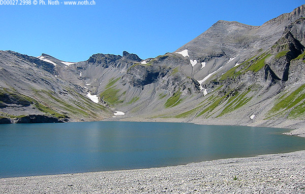
So then you leave the parking of the Barrage d’Emosson (it is possible to get there by train and by a funicular), you pass the dam and then you follow the little asphalt road closely following the contours of Lake Emosson. 45 minutes later, the road does not go along the right shore of the lake any more. Instead, it goes steep up through 2 tunnels towards the second lake, Vieux Emosson. There you’ll find another bar. You can go round this lake by taking the left shore, this time. There is a little digression: the bank of a river is defined in relation to what direction it flows. I guess that the same applies for a lake. As the Vieux Emosson lake empties into the Gorge du Vieux, at the level of the bar, the left bank is in the north while the right bank in the south. End of the digression. Here the road finally comes to an end and turns into a path. A path with no slope, crossing a rocky and barren terrain. In fact you are walking on the shore of the Vieux Emosson lake (photo 2). Again, you need 45 minutes to reach the place where the path leaves the lake level. It first rises into a pasture, then a scree. After going up for 30-35 minutes, you reach the site of the dinosaurs.

I think that it is difficult for non-palaeontologists to see what is interesting about the dinosaur traces, although these ocean wave marks at 2500 meters of altitude brings you to question how it all happened. During the summer, one or several scientists are appointed to provide explanations. Please also note that according to other documents, the site is covered with a firn until quite late, so that you should wait for the second half of the summer to be sure to see the traces.
As there are quite some people, it is advisable to pursue to the Col des Corbeaux to find a quiet place for a picnic: 30 minutes on a steep slope of scree made of slate, I think. On the right another path passes under the Pointe aux Corbeaux and leads to the Col du Vieux or to the Cheval Blanc. We especially found pleasure in this hike thanks to the countryside rather than thanks to the prehistoric footsteps, and the Col des Corbeaux is far from being disappointing: behind the Buet in the foreground and the Aiguiles Rouge de Chamonix in the background, you have the Mont Blanc right there in front of you.

You need 30 more minutes to go from the Col des Corbeaux to the Col de Terrasse via the pretty Lac Vert. When you start going down from the Col de Terrasse to Loria, you enter France. It's quite impressive because the slope is very steep here, especially at the beginning (just like the ski slope of Chanavette for those who know it). All the while going down, the meadows reappear and announce the chalets of Loria (1h from the pass). The place is comfortable. The water is drinkable, including at the fountain. The chalets are lined up to form a small street. The restaurant serves delicious fruit tarts.
You still have to return to La Gueulaz. Looking at the map, this seems easy because the altitude does not vary. Mere formality? Not at all! After 45 easy minutes on a beautiful balcony facing the French Alps, you arrive on grassy slopes interspersed with fairly steep cliffs. Passing there becomes trickier. It’s not really all that difficult but you are not so very happy to trudge along there after 8 hours of walking because the tiredness decreases the attention. You must cross numerous rocky passages made up of high steps, of which one of them is equipped with chains. There are, in addition and especially in the end, several uphills. You finally reach the dam and the parking of La Gueulaz.
If this 7-8 hour circuit seems too long, choose the alternative which is completely on Swiss territory and which consists in returning to the dinosaur site going by the La Veudale gorge. Search for "veudale" in Google and you will get more information.
Readers' comments:
 From: Jérôme Girardin

                  Sent: 24-Aug-2016


                  (...)

                  Because of the work around Vieux Emosson, the itinerary you describe
                  has been slightly modified. Now the hikers have to walk to the left of
                  the lake, and not to the right. [translated from French]

