
In short:
- Starting point: hamlet of Le Flon (parking or postal bus)
- Total duration: 6-7 hours
- Difficulty: T2 - Mountain Hikes
- KMZ file for Google Earth
- GPX track for GPS
- Profile (roundtrip):
- Aloneness index:

Maps:
- Extracts:
1:25'000 1:50'000 1:200'000 - Swisstopo shop:
Not very handy! The itinerary crosses the boundaries of several national maps.
Links (click on flag):
 Report and pictures on Randomandie.ch. Note: this is an other itinerary, starting in France. It is considered more dangerous than the one I suggest here.
- The same excursion, made in the reverse direction, by Markus Jaton.
 Cornettes de Bise and Col de Verne, a personal account by Mr Peck, in his quite peculiar writing style :) Taken from Dwight Peck's personal Web site.
Col de Verne, Cornettes de Bise, Lac de Tanay (Taney)
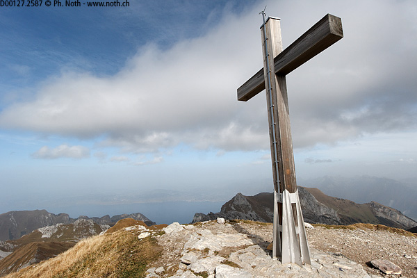
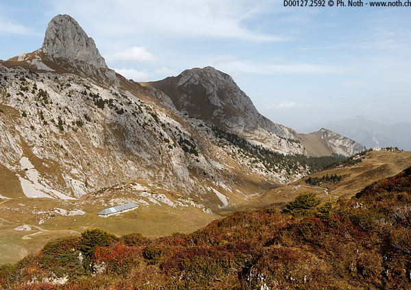
As the highest peak of the Chablais region on the French-Swiss border, the Cornettes de Bise (2432m, 7979ft) provides a resplendent balcony overlooking Lac Léman and the Prealps. The gradual climb up to the Col de Verne followed by the descent to the Tanay lake offers a varied itinerary, just long and hard enough to combine sport and pleasure.
I had delayed this project for a long time due to reports of the climb being quite difficult with "several vertiginous exposed sections requiring extra care" (quote translated from www.randos-montblanc.com) but in fact this refers to the French route. The itinerary described here is almost entirely on Swiss ground and is not of any difficulty. Some say that you'll meet many walkers at the summit and see chamois scampering around on its slopes, however I saw nothing with two, four, six or even eight legs. Nothing at all! Even the bouquetins, which are normally legion in the Chablais mountains (around the Col de Bise and the Crêtes de Charousse), seemed to be hiding from me. One would have thought that the animals must be trained to come out only on weekends! Anyway, the walk was perfect for unwinding even though completely barren as wildlife goes.

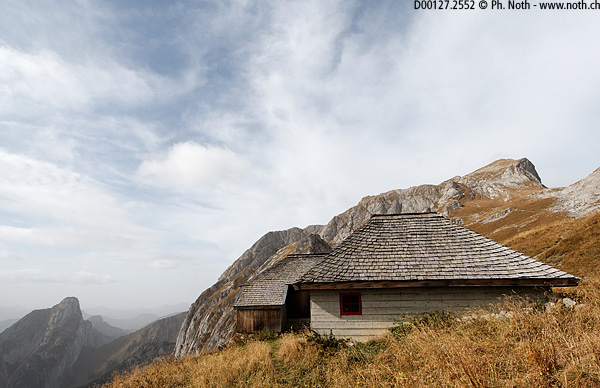

Start from Le Flon, as for the Grammont walk. Do note that the car park gets packed out on weekends. Most people walk to Taney (Tanay). We, on the other hand, will go down a few metres to find the road towards the Col de Verne. After about ½ hr, the tarmac road turns into a forestry track, and then a typical alpine meadow path since it comes out of the woods near to Plan de l'Ortie. The pass can been seen readily from here but, according to the signpost, it is still 1 hr 25 min away. The itinerary continues to climb this pretty little valley in a more or less straight line. Much further up, near a goat farm (called Le Coeur), the path leads away to the right. A sign will tell you that it's forbidden to drive up here but gives no instructions for walkers. Never mind, the pass is not far away. Continue straight on behind the house towards the pass (follow an animal trail that subsequently turns into a small path).
The Col de Verne (1814m, 5951ft), also called Col de Vernaz, is on the French border, as you will notice since the style used for walking directions changes. At this point, we will have been walking for about 2 hrs. Several paths leave the pass. One leads down the French side and another heads off towards the Arvouin lake. A third path (follow this one) for the Cornettes de Bise climbs up the steep grassy southern slopes to the right towards the La Calaz farm. From the farmhouse you can try to make out the rest of the climb and the cross on the summit. The top of the peak is formed by a combination of rocky crags and meadows.
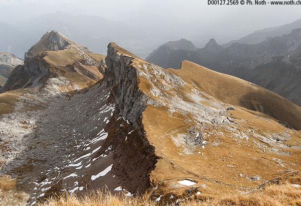
After a beautiful traverse, you'll reach a pass with no name near the Rochers de Chaudin (altitude 2250m). This is where the descent starts towards Taney. However, first let's climb the Cornettes de Bise, the summit is so close that you should fly up it. Be careful though to stay away from the abrupt cliffs on the northern side. You should reach the cross after an overall climb of about 3½ hrs. The panorama is stunning over the Grammont, the Pucelles, Lac Léman, the Rhône valley and of course the high peaks of the Alps if the weather is clear enough (unfortunately it wasn't brilliant for me).
The way down starts by going back to the pass near the Rochers de Chaudin. From here the path plunges down into a very quiet and wild valley called the Chaux du Milieu. You'll cross much scree and if you look back towards the summit you'll be hard pushed to believe you were actually up there: as seen from the valley, the Cornettes de Bise now look quite off-putting. The path leading down is marked out in red and winds through enormous boulders and limestone pavements. Then, it takes a strong left round a shoulder followed by a wide curve through the Traverses and Crosets alpine meadows before reaching the Loz farms. Be careful not to continue down the Chaux du Milieu valley otherwise you'll find yourself back in the Verne valley.
The descent to the Loz farms lasted about 1½ hr and from there a signpost will show you the way to Taney. From here on the walk is much easier: a lane leads down to the Taney lake and village even though you can choose to take a short cut via Echerches. At Taney, as for the Grammont walk, you might like to stop off for a rest and a nibble, before heading back down the steep tarmac road. Overall the descent is quite gentle and lasts about 3 hrs.
