In short:
- Starting point: Alpage de Chamosentse, 1908m ou Alpage de Loutse, 1721m
- Total duration: 4h15 - 6h15 (+ 45min from Loutse)
- Difficulty: T2 - Mountain Hikes
- KMZ file for Google Earth
- Profile:

- Aloneness index:

Maps:
Links (click on flag):
Tour de la Dent de Chamosentse, col de la Forcla, lac de la Forcla
This circuit was recently inaugurated by the municipality of Chamoson on 31st July 2011. A lake, a tooth, two passes: the stage is set. As to the scenario, it is described in a free guidebook, Les Hauts de Chamoson.
This itinerary provides a walk through geological time, and your level of enthusiasm for such knowledge will determine how you go about this outing. If you are simply not interested you won't need to bother about even opening the guidebook and you can be back in Chamosentse within 3h15 (4h from Loutse). This is the walking time calculated on the SwitzerlandMobility Plus website and does not account for anything but walking. On the other hand, enthusiasts who stop off to inspect the different geological sites described in the guidebook should count 5-6 hours (the guidebook says 6h10 from Chamosentse).
In the description provided in the guidebook, the authors aspire to make this geology trail a well-known outing in the region, however after doing it myself, it is far from the case for the moment. I would only award this walk an aloneness grade of 1, because the nearby Col de la Forcla and the Forcla lake are on the Tour des Muverans trail and attract a fair number of hikers. Still, you will experience a certain amount of quality aloneness on the way up via the Pas de Chamosentse. Several reasons make me hopeful that this walk will never get over visited:
- the length of the circuit: indeed 6h walking should deter many;
- its relatively recent description: more than a few years are needed before a new itinerary becomes well known, and even if local media have mentioned it, it is not included in most guidebooks;
- its inaccessibility via public transport: getting to Chamosentse in your car is quite an expedition, reaching Loutze is easier by this makes the hike 45 minutes longer.

As well as simply admiring the landscape you cross on this walk, you will able to see and understand what a funnel-shaped sinkhole, supraglacial stream, rock joints, kame, mollisol, vergence or Würm are or mean (and many other things) ... or ponder on the difference between shale schist and schist-like shale.
This circuit is generally started at the alpine farm of Chamosentse, at an altitude of 1908 meters. A tarmac road reaches Loutze from Ovronnaz. The rest of the drive is along a bumpy alpine track. A number of footpath signs can be found on the farm building. Take the path to the left of the building towards the Col de la Forcla. You will only cross this pass on the way back down, but this is the right way to go to start with. No gentle warm up! The path heads straight up the steep grassy slopes towards the flatter Tsanrion area (spelt Chanrion in the guidebook).
At the first crossing, also the 3rd geological site mentioned in the guide [2042m, 30min], leave the Outannes valley to your left. You will come down this way via the Cabane Rambert. The path to take heads right and crosses horizontally under the base of the south face of the tooth-shaped Dent de Chamosentse.
A cable is provided at Les Palantsons to help you safely up a rocky outcrop. The climb now gets more strenuous. The path alternates between the banks of the Chamosentse torrent and climbs towards the Pas de Chamosentse (Chamosentse step). Areas of short grass follow ordinary scree interspersed with more interesting geological landforms: a bare limestone slab, rocks striated by the ice of former glaciers, etc. All of which are beautifully described in the guidebook (that can be picked up in Chamoson or on internet). Flowers can be found here, which is not the case at all on the second part of the circuit. In July, yellow hues are the most common.
The so-called Pas de Chamosentse [2454m, 2h] where one would expect a ledge to cross, break in the ground or some kind of tricky step is actually completely uneventful without even a sign. Gradually the slopes have got gentler and the path crosses flatter land, and enters the upper Derbonne valley in a smooth, sensible manner. Snow persists a long time in this depression that lies under the elegant silhouettes of the Tita Naire and Le Pacheu peaks and harbors the Forcla lake. Along the sides of the path, and with the help of the descriptions in the guidebook, you will be able to spot limestone pavement formations and folded rock.
Go round the lake (or "étang" = pond, on the Swiss national map) via its northern side. Contrasting with the turquoise or emerald color of other Alpine lakes, the waters of the Forcla lake are of a deeper, Turquin blue color. A rather sad blue-gray hue but that fits well in this very rocky setting.

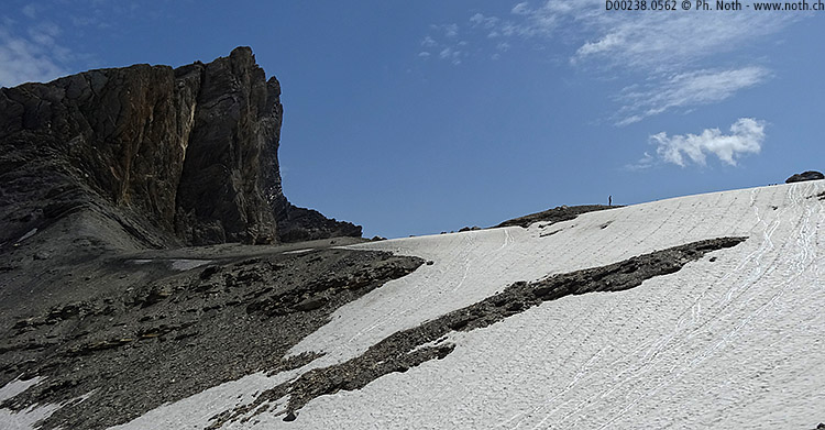
The pass of the Col de la Forcla lies only 100 meters above the lake, and to reach it you will climb a slope covered with large rocks or a patch of persistent snow. Several signposts provide information for hikers at the pass [2547m, 3h]. The view towards the gigantic geological folds of the Dent de Chamosentse is fascinating.
The way back down the southern slopes starts with a steep portion of stone scree. Then it heads completely to the right across the slope, a seemingly useless detour towards the Cabane Rambert instead of heading straight down the Outannes valley. Perhaps the risk of stone fall under the Dent de Chamonsentse is so pronounced that it is safer to make such a detour. Finally, when you reach the crossing for Rambert [2387m, 3h30], take the left path that leads down the valley. In just 30 minutes, following the path down the middle of the Outannes valley (sometimes still covered with snow), you will reach the path you climbed this morning, and then after another 15min the Chamosentse farm.
And if so wished, you can delay your return to civilization by stopping off at the Buvette de Loutze. Reservation recommended.


This hike is featured in the book
Randonnées pour Grizzlys
Alpes valaisannes
published in 2013 by the editor Slatkine.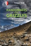
The book can be ordered online at the Slatkine website or bought in any good bookstore of French-speaking Switzerland